Jacala geodata
Jacala (Hidalgo) is a populated place; located in Mexico in America/Mexico_City (GMT-6) time zone. With population of 4,415 people, there are 2079 cities with bigger population in this country. Compared to other cities in Mexico, 76.6% of cities are located further ↓South; 52.6% of cities are located further →East and 51.5% of cities have higher elevation than Jacala. Note1


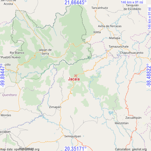
Jacala GPS coordinates[2]
21° 0' 34.272" North, 99° 11' 28.824" West
| Map corner | latitude | longitude |
|---|---|---|
| Upper-left | 21.66445°, | -99.89447° |
| Center: | 21.00952°, | -99.19134° |
| Lower-right: | 20.35171°, | -98.48822° |
| Map W x H: | 146×146 km | = 90.7×90.7mi |
| max Lat: | 32.7° ⇑23.4% North |
| Jacala: | 21.00952° |
| min Lat: | ⇓76.6% South 14.53588° |
| min Long | Jacala | max Long |
| -117.105° | -99.19134° | -86.73105° |
| W 47.4%⇐ | ⇒52.6% E |
Elevation
Elevation of Jacala is 1360 m = 4462 ft, and this is 106.3 m = 349 ft above average elevation for this country.
| Max E: |
3497 m = 11473 ft | 51.5% |
| Jacala | 1360 m 4462 ft | |
| Avg. | 1253.7 m = 4113 ft | |
Min E: |
-1 m = -3 ft | 48.5% |
See also: Mexico elevation on elevation.city.
Geographical zone
Jacala is located in North Torrid zone (between Equator and Tropic of Cancer). Distance of this Northern Tropic circle is 269.9 km =167.7 mi to North.| Distance of | km | miles | from Jacala |
|---|---|---|---|
| North Pole | 7671 | 4766.5 | to North |
| Arctic Circle | 5065.1 | 3147.3 | to North |
| Tropic Cancer | 269.9 | 167.7 | to North |
| Equator | 2336 | 1451.5 | to South |


Nearby cities:
15 places around Jacala: (largest is in red/bold)
• Coñecito
7.9 km =4.9 mi,  61°
61°
• Cuesta Colorada
7.9 km =4.9 mi,  76°
76°
• Durango
13 km =8.1 mi,  199°
199°
• El Coyol
20.8 km =12.9 mi,  73°
73°
• El Pinalito
3.3 km =2.1 mi, 63°
• Jiliapan
16.1 km =10 mi,  258°
258°
• La Misión
12.2 km =7.6 mi,  35°
35°
• La Palma
19.9 km =12.4 mi,  137°
137°
• Las Duraznos
9 km =5.6 mi, 40°
• Otates
15.3 km =9.5 mi,  350°
350°
• Pacula
11.8 km =7.3 mi,  292°
292°
• Plomosas
11.1 km =6.9 mi,  168°
168°
• San Nicolás
7.6 km =4.7 mi,  158°
158°
• Tilaco
17.2 km =10.7 mi,  359°
359°
• Vicente Guerrero
13.3 km =8.3 mi, 290°
Sources, notices
• [Note1] Compared only with cities in Mexico existing in our database
• [Src1] Map data: © OpenStreetMap contributors (CC-BY-SA)
• [Src2] Other city data from geonames.org with taken over terms of usage.
• [Src3] Geographical zone / Annual Mean Temperature by Robert A. Rohde @ Wikipedia
