Jiliapan geodata
Jiliapan (Hidalgo) is a populated place; located in Mexico in America/Mexico_City (GMT-6) time zone. With population of 966 people, there are 9007 cities with bigger population in this country. Compared to other cities in Mexico, 76.2% of cities are located further ↓South; 54.8% of cities are located further →East and 50.5% of cities have lower elevation than Jiliapan. Note1


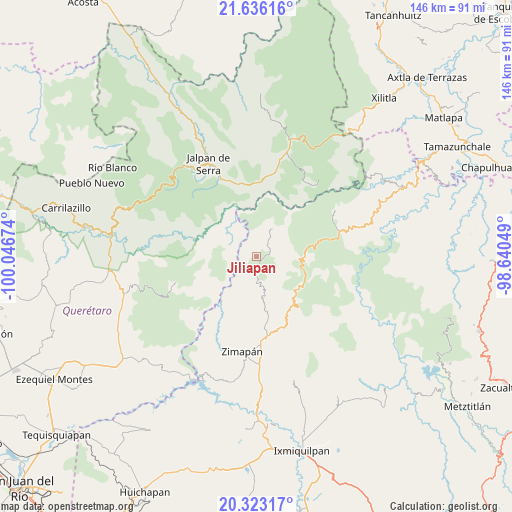
Jiliapan GPS coordinates[2]
20° 58' 51.996" North, 99° 20' 36.996" West
| Map corner | latitude | longitude |
|---|---|---|
| Upper-left | 21.63616°, | -100.04674° |
| Center: | 20.98111°, | -99.34361° |
| Lower-right: | 20.32317°, | -98.64049° |
| Map W x H: | 146×146 km | = 90.7×90.7mi |
| max Lat: | 32.7° ⇑23.8% North |
| Jiliapan: | 20.98111° |
| min Lat: | ⇓76.2% South 14.53588° |
| min Long | Jiliapan | max Long |
| -117.105° | -99.34361° | -86.73105° |
| W 45.2%⇐ | ⇒54.8% E |
Elevation
Elevation of Jiliapan is 1455 m = 4774 ft, and this is 201.3 m = 660 ft above average elevation for this country.
| Max E: |
3497 m = 11473 ft | 49.5% |
| Jiliapan | 1455 m 4774 ft | |
| Avg. | 1253.7 m = 4113 ft | |
Min E: |
-1 m = -3 ft | 50.5% |
See also: Mexico elevation on elevation.city.
Geographical zone
Jiliapan is located in North Torrid zone (between Equator and Tropic of Cancer). Distance of this Northern Tropic circle is 273 km =169.6 mi to North.| Distance of | km | miles | from Jiliapan |
|---|---|---|---|
| North Pole | 7674.2 | 4768.5 | to North |
| Arctic Circle | 5068.3 | 3149.3 | to North |
| Tropic Cancer | 273 | 169.6 | to North |
| Equator | 2332.9 | 1449.6 | to South |


Nearby cities:
15 places around Jiliapan: (largest is in red/bold)
• Coñecito
23.8 km =14.8 mi,  72°
72°
• Cuesta Colorada
24.1 km =15 mi,  77°
77°
• Durango
14.6 km =9.1 mi,  128°
128°
• El Pinalito
19.3 km =12 mi, 76°
• Jacala
16.1 km =10 mi, 78°
• Landa de Matamoros
22.8 km =14.2 mi,  6°
6°
• Las Duraznos
23.8 km =14.8 mi, 65°
• Maconí
25.5 km =15.8 mi,  230°
230°
• Otates
22.5 km =14 mi,  35°
35°
• Pacula
9.2 km =5.7 mi,  32°
32°
• Plomosas
19.6 km =12.2 mi,  113°
113°
• San Joaquín
24.1 km =15 mi,  252°
252°
• San Nicolás
19 km =11.8 mi,  101°
101°
• Tilaco
25.6 km =15.9 mi, 37°
• Vicente Guerrero
8.6 km =5.3 mi,  22°
22°
Sources, notices
• [Note1] Compared only with cities in Mexico existing in our database
• [Src1] Map data: © OpenStreetMap contributors (CC-BY-SA)
• [Src2] Other city data from geonames.org with taken over terms of usage.
• [Src3] Geographical zone / Annual Mean Temperature by Robert A. Rohde @ Wikipedia
