Vicente Guerrero geodata
Vicente Guerrero (Hidalgo) is a populated place; located in Mexico in America/Mexico_City (GMT-6) time zone. With population of 613 people, there are 14065 cities with bigger population in this country. Compared to other cities in Mexico, 77.2% of cities are located further ↓South; 54.3% of cities are located further →East and 52% of cities have higher elevation than Vicente Guerrero. Note1


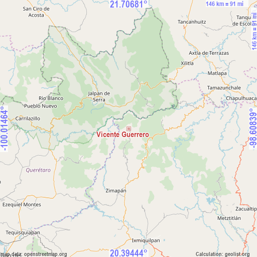
Vicente Guerrero GPS coordinates[2]
21° 3' 7.452" North, 99° 18' 41.436" West
| Map corner | latitude | longitude |
|---|---|---|
| Upper-left | 21.70681°, | -100.01464° |
| Center: | 21.05207°, | -99.31151° |
| Lower-right: | 20.39444°, | -98.60839° |
| Map W x H: | 145.9×145.9 km | = 90.7×90.7mi |
| max Lat: | 32.7° ⇑22.8% North |
| Vicente Guerrero: | 21.05207° |
| min Lat: | ⇓77.2% South 14.53588° |
| min Long | Vicente Guerrer | max Long |
| -117.105° | -99.31151° | -86.73105° |
| W 45.7%⇐ | ⇒54.3% E |
Elevation
Elevation of Vicente Guerrero is 1338 m = 4390 ft, and this is 84.3 m = 277 ft above average elevation for this country.
| Max E: |
3497 m = 11473 ft | 52% |
| Vicente Guerrero | 1338 m 4390 ft | |
| Avg. | 1253.7 m = 4113 ft | |
Min E: |
-1 m = -3 ft | 48% |
See also: Mexico elevation on elevation.city.
Geographical zone
Vicente Guerrero is located in North Torrid zone (between Equator and Tropic of Cancer). Distance of this Northern Tropic circle is 265.1 km =164.7 mi to North.| Distance of | km | miles | from Vicente Guerrero |
|---|---|---|---|
| North Pole | 7666.3 | 4763.6 | to North |
| Arctic Circle | 5060.4 | 3144.4 | to North |
| Tropic Cancer | 265.1 | 164.7 | to North |
| Equator | 2340.8 | 1454.5 | to South |


Nearby cities:
15 places around Vicente Guerrero: (largest is in red/bold)
• Coñecito
19.4 km =12.1 mi,  92°
92°
• Cuesta Colorada
20.4 km =12.7 mi,  98°
98°
• Durango
18.8 km =11.7 mi,  154°
154°
• El Pinalito
15.7 km =9.8 mi, 102°
• Jacala
13.3 km =8.3 mi,  110°
110°
• Jiliapan
8.6 km =5.3 mi,  202°
202°
• La Lagunita
22.4 km =13.9 mi,  14°
14°
• La Misión
20.2 km =12.6 mi,  75°
75°
• Landa de Matamoros
14.8 km =9.2 mi,  356°
356°
• Las Duraznos
18.4 km =11.4 mi, 83°
• Otates
14.3 km =8.9 mi,  43°
43°
• Pacula
1.6 km =1 mi, 95°
• Plomosas
21.4 km =13.3 mi,  136°
136°
• San Nicolás
19.3 km =12 mi,  127°
127°
• Tilaco
17.4 km =10.8 mi, 44°
Sources, notices
• [Note1] Compared only with cities in Mexico existing in our database
• [Src1] Map data: © OpenStreetMap contributors (CC-BY-SA)
• [Src2] Other city data from geonames.org with taken over terms of usage.
• [Src3] Geographical zone / Annual Mean Temperature by Robert A. Rohde @ Wikipedia
