Ixcatepec geodata
Ixcatepec (Morelos) is a section of populated place; located in Mexico in America/Mexico_City (GMT-6) time zone. With population of 786 people, there are 11112 cities with bigger population in this country. Compared to other cities in Mexico, 65.1% of cities are located further ↑North; 50.8% of cities are located further →East and 56.9% of cities have lower elevation than Ixcatepec. Note1


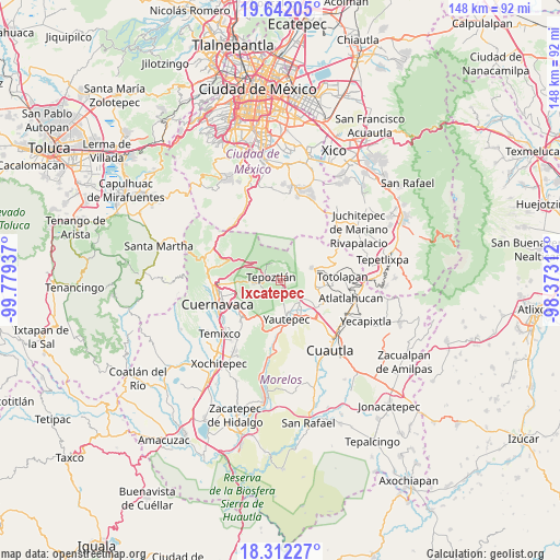
Ixcatepec GPS coordinates[2]
18° 58' 42.564" North, 99° 4' 34.464" West
| Map corner | latitude | longitude |
|---|---|---|
| Upper-left | 19.64205°, | -99.77937° |
| Center: | 18.97849°, | -99.07624° |
| Lower-right: | 18.31227°, | -98.37312° |
| Map W x H: | 147.9×147.9 km | = 91.9×91.9mi |
| max Lat: | 32.7° ⇑65.1% North |
| Ixcatepec: | 18.97849° |
| min Lat: | ⇓34.9% South 14.53588° |
| min Long | Ixcatepec | max Long |
| -117.105° | -99.07624° | -86.73105° |
| W 49.2%⇐ | ⇒50.8% E |
Elevation
Elevation of Ixcatepec is 1653 m = 5423 ft, and this is 399.3 m = 1310 ft above average elevation for this country.
| Max E: |
3497 m = 11473 ft | 43.1% |
| Ixcatepec | 1653 m 5423 ft | |
| Avg. | 1253.7 m = 4113 ft | |
Min E: |
-1 m = -3 ft | 56.9% |
See also: Mexico elevation on elevation.city.
Geographical zone
Ixcatepec is located in North Torrid zone (between Equator and Tropic of Cancer). Distance of this Northern Tropic circle is 495.7 km =308 mi to North.| Distance of | km | miles | from Ixcatepec |
|---|---|---|---|
| North Pole | 7896.9 | 4906.9 | to North |
| Arctic Circle | 5291 | 3287.7 | to North |
| Tropic Cancer | 495.7 | 308 | to North |
| Equator | 2110.2 | 1311.2 | to South |


Nearby cities:
15 places around Ixcatepec: (largest is in red/bold)
• Amatlán de Quetzalcoatl
4.1 km =2.5 mi,  94°
94°
• Colonia Huilotepec
1.2 km =0.7 mi,  154°
154°
• Colonia Obrera
6.5 km =4 mi,  142°
142°
• Colonia Ángel Bocanegra (Adolfo López Mateos)
7.6 km =4.7 mi, 139°
• El Golán
8.2 km =5.1 mi,  120°
120°
• El Zarco
6.7 km =4.2 mi,  170°
170°
• Ignacio Bastida (Santa Catarina Tlayca)
7.8 km =4.8 mi, 123°
• Las Vivianas
7.4 km =4.6 mi, 135°
• Lázaro Cárdenas (El Empalme)
7.4 km =4.6 mi,  133°
133°
• Oacalco
7.9 km =4.9 mi, 141°
• San Andrés de la Cal
4.7 km =2.9 mi,  239°
239°
• Santa Catarina
6.8 km =4.2 mi,  261°
261°
• Santiago Tepetlapa
1.4 km =0.9 mi,  175°
175°
• Santo Domingo Ocotitlán
4.3 km =2.7 mi,  21°
21°
• Tepoztlán
2.7 km =1.7 mi,  288°
288°
Sources, notices
• [Note1] Compared only with cities in Mexico existing in our database
• [Src1] Map data: © OpenStreetMap contributors (CC-BY-SA)
• [Src2] Other city data from geonames.org with taken over terms of usage.
• [Src3] Geographical zone / Annual Mean Temperature by Robert A. Rohde @ Wikipedia
