El Golán geodata
El Golán (Morelos) is a populated place; located in Mexico in America/Mexico_City (GMT-6) time zone. With population of 719 people, there are 12132 cities with bigger population in this country. Compared to other cities in Mexico, 66.1% of cities are located further ↑North; 50% of cities are located further ←West and 51.8% of cities have higher elevation than El Golán. Note1


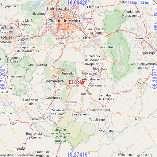
El Golán GPS coordinates[2]
18° 56' 26.016" North, 99° 0' 32.004" West
| Map corner | latitude | longitude |
|---|---|---|
| Upper-left | 19.60428°, | -99.71202° |
| Center: | 18.94056°, | -99.00889° |
| Lower-right: | 18.27419°, | -98.30577° |
| Map W x H: | 147.9×147.9 km | = 91.9×91.9mi |
| max Lat: | 32.7° ⇑66.1% North |
| El Golán: | 18.94056° |
| min Lat: | ⇓33.9% South 14.53588° |
| min Long | El Golán | max Long |
| -117.105° | -99.00889° | -86.73105° |
| W 50%⇐ | ⇒50% E |
Elevation
Elevation of El Golán is 1351 m = 4432 ft, and this is 97.3 m = 319 ft above average elevation for this country.
| Max E: |
3497 m = 11473 ft | 51.8% |
| El Golán | 1351 m 4432 ft | |
| Avg. | 1253.7 m = 4113 ft | |
Min E: |
-1 m = -3 ft | 48.2% |
See also: Mexico elevation on elevation.city.
Geographical zone
El Golán is located in North Torrid zone (between Equator and Tropic of Cancer). Distance of this Northern Tropic circle is 499.9 km =310.6 mi to North.| Distance of | km | miles | from El Golán |
|---|---|---|---|
| North Pole | 7901.1 | 4909.5 | to North |
| Arctic Circle | 5295.2 | 3290.3 | to North |
| Tropic Cancer | 499.9 | 310.6 | to North |
| Equator | 2106 | 1308.6 | to South |


Nearby cities:
15 places around El Golán: (largest is in red/bold)
• Amatlán de Quetzalcoatl
4.9 km =3 mi,  322°
322°
• Colonia Obrera
3.3 km =2.1 mi,  252°
252°
• Colonia Puente Pantitlán
2.9 km =1.8 mi,  137°
137°
• Colonia Ángel Bocanegra (Adolfo López Mateos)
2.7 km =1.7 mi,  234°
234°
• Corral Grande
4.3 km =2.7 mi,  107°
107°
• Emiliano Zapata (Casahuates)
5.4 km =3.4 mi,  101°
101°
• Ignacio Bastida (Santa Catarina Tlayca)
0.6 km =0.4 mi,  266°
266°
• Itzamatitlán
3.7 km =2.3 mi,  202°
202°
• Las Vivianas
2.2 km =1.4 mi,  241°
241°
• Los Arcos
6.1 km =3.8 mi, 195°
• Lázaro Cárdenas (El Empalme)
2 km =1.2 mi, 241°
• Nacatongo
3.1 km =1.9 mi,  80°
80°
• Oacalco
2.9 km =1.8 mi, 228°
• Oaxtepec
6 km =3.7 mi, 114°
• Tlayacapan
3.4 km =2.1 mi,  60°
60°
Sources, notices
• [Note1] Compared only with cities in Mexico existing in our database
• [Src1] Map data: © OpenStreetMap contributors (CC-BY-SA)
• [Src2] Other city data from geonames.org with taken over terms of usage.
• [Src3] Geographical zone / Annual Mean Temperature by Robert A. Rohde @ Wikipedia
