El Zarco geodata
El Zarco (Morelos) is a populated place; located in Mexico in America/Mexico_City (GMT-6) time zone. With population of 698 people, there are 12480 cities with bigger population in this country. Compared to other cities in Mexico, 66.6% of cities are located further ↑North; 50.7% of cities are located further →East and 54.2% of cities have higher elevation than El Zarco. Note1


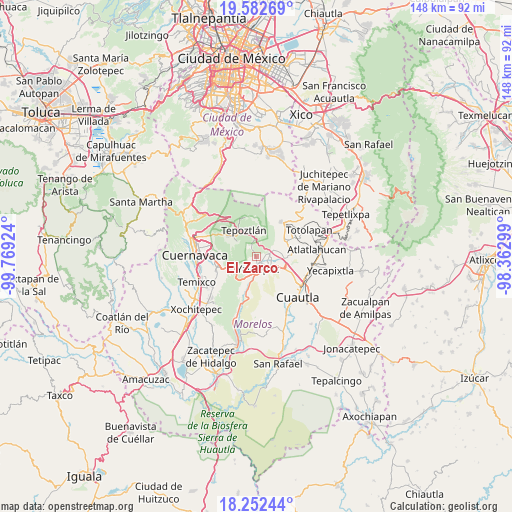
El Zarco GPS coordinates[2]
18° 55' 8.004" North, 99° 3' 57.996" West
| Map corner | latitude | longitude |
|---|---|---|
| Upper-left | 19.58269°, | -99.76924° |
| Center: | 18.91889°, | -99.06611° |
| Lower-right: | 18.25244°, | -98.36299° |
| Map W x H: | 147.9×147.9 km | = 91.9×91.9mi |
| max Lat: | 32.7° ⇑66.6% North |
| El Zarco: | 18.91889° |
| min Lat: | ⇓33.4% South 14.53588° |
| min Long | El Zarco | max Long |
| -117.105° | -99.06611° | -86.73105° |
| W 49.3%⇐ | ⇒50.7% E |
Elevation
Elevation of El Zarco is 1234 m = 4049 ft, and this is 19.7 m = 65 ft below average elevation for this country.
| Max E: |
3497 m = 11473 ft | 54.2% |
| Avg. | 1253.7 m = 4113 ft | |
| El Zarco | 1234 m = 4049 ft | |
Min E: |
-1 m = -3 ft | 45.8% |
See also: Mexico elevation on elevation.city.
Geographical zone
El Zarco is located in North Torrid zone (between Equator and Tropic of Cancer). Distance of this Northern Tropic circle is 502.3 km =312.1 mi to North.| Distance of | km | miles | from El Zarco |
|---|---|---|---|
| North Pole | 7903.5 | 4911 | to North |
| Arctic Circle | 5297.6 | 3291.8 | to North |
| Tropic Cancer | 502.3 | 312.1 | to North |
| Equator | 2103.6 | 1307.1 | to South |


Nearby cities:
15 places around El Zarco: (largest is in red/bold)
• Colonia Huilotepec
5.6 km =3.5 mi,  354°
354°
• Colonia Obrera
3.2 km =2 mi,  63°
63°
• Colonia Ángel Bocanegra (Adolfo López Mateos)
3.9 km =2.4 mi,  77°
77°
• El Caudillo del Sur
6.6 km =4.1 mi,  203°
203°
• El Golán
6.5 km =4 mi,  68°
68°
• Ignacio Bastida (Santa Catarina Tlayca)
5.9 km =3.7 mi, 66°
• Itzamatitlán
4.7 km =2.9 mi,  102°
102°
• Ixcatepec
6.7 km =4.2 mi, 350°
• Las Vivianas
4.3 km =2.7 mi, 71°
• Los Arcos
5.6 km =3.5 mi,  128°
128°
• Lázaro Cárdenas (El Empalme)
4.5 km =2.8 mi, 70°
• Oacalco
3.9 km =2.4 mi, 82°
• San Andrés de la Cal
6.6 km =4.1 mi,  309°
309°
• Santiago Tepetlapa
5.3 km =3.3 mi, 349°
• Yautepec
4.1 km =2.5 mi,  181°
181°
Sources, notices
• [Note1] Compared only with cities in Mexico existing in our database
• [Src1] Map data: © OpenStreetMap contributors (CC-BY-SA)
• [Src2] Other city data from geonames.org with taken over terms of usage.
• [Src3] Geographical zone / Annual Mean Temperature by Robert A. Rohde @ Wikipedia
