Hidalgo geodata
Hidalgo (Tamaulipas) is a populated place; located in Mexico in America/Matamoros (GMT-5) time zone. With population of 4,810 people, there are 1924 cities with bigger population in this country. Compared to other cities in Mexico, 95.4% of cities are located further ↓South; 61.2% of cities are located further ←West and 87.2% of cities have higher elevation than Hidalgo. Note1


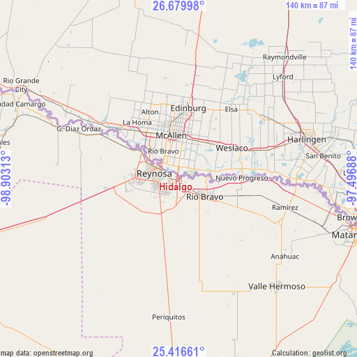
Hidalgo GPS coordinates[2]
26° 3' 0" North, 98° 12' 0" West
| Map corner | latitude | longitude |
|---|---|---|
| Upper-left | 26.67998°, | -98.90313° |
| Center: | 26.05°, | -98.2° |
| Lower-right: | 25.41661°, | -97.49688° |
| Map W x H: | 140.5×140.5 km | = 87.3×87.3mi |
| max Lat: | 32.7° ⇑4.6% North |
| Hidalgo: | 26.05° |
| min Lat: | ⇓95.4% South 14.53588° |
| min Long | Hidalgo | max Long |
| -117.105° | -98.2° | -86.73105° |
| W 61.2%⇐ | ⇒38.8% E |
Elevation
Elevation of Hidalgo is 33 m = 108 ft, and this is 1220.7 m = 4005 ft below average elevation for this country.
| Max E: |
3497 m = 11473 ft | 87.2% |
| Avg. | 1253.7 m = 4113 ft | |
| Hidalgo | 33 m = 108 ft | |
Min E: |
-1 m = -3 ft | 12.8% |
See also: Mexico elevation on elevation.city.
Geographical zone
Hidalgo is located in North temperate zone (between Tropic of Cancer and the Arctic Circle). Distance of this Northern Tropic circle is 290.6 km =180.6 mi to South.| Distance of | km | miles | from Hidalgo |
|---|---|---|---|
| North Pole | 7110.6 | 4418.3 | to North |
| Arctic Circle | 4504.7 | 2799.1 | to North |
| Tropic Cancer | 290.6 | 180.6 | to South |
| Equator | 2896.5 | 1799.8 | to South |


Nearby cities:
15 places around Hidalgo: (largest is in red/bold)
• Ampliación Río Bravo
14.2 km =8.8 mi,  149°
149°
• Argüelles
31.2 km =19.4 mi,  299°
299°
• Brecha 124 con Vía de FFCC
24 km =14.9 mi,  105°
105°
• Ciudad Gustavo Díaz Ordaz
44.4 km =27.6 mi, 297°
• Ciudad Río Bravo
12.7 km =7.9 mi,  123°
123°
• El Control
40 km =24.9 mi,  104°
104°
• Empalme
42.7 km =26.5 mi, 113°
• Ensenada
38.8 km =24.1 mi, 121°
• Ignacio Manuel Altamirano
41.9 km =26 mi, 114°
• Los Cavazos
18.1 km =11.2 mi,  306°
306°
• Nuevo Progreso
24.8 km =15.4 mi,  88°
88°
• Presidente Cárdenas
43.3 km =26.9 mi, 111°
• Ramírez
42.8 km =26.6 mi, 104°
• Reynosa
9.5 km =5.9 mi,  291°
291°
• Vamos Tamaulipas
7.4 km =4.6 mi,  197°
197°
Sources, notices
• [Note1] Compared only with cities in Mexico existing in our database
• [Src1] Map data: © OpenStreetMap contributors (CC-BY-SA)
• [Src2] Other city data from geonames.org with taken over terms of usage.
• [Src3] Geographical zone / Annual Mean Temperature by Robert A. Rohde @ Wikipedia
