Esperanza geodata
Esperanza (Puebla) is a seat of a second-order administrative division; located in Mexico in America/Mexico_City (GMT-6) time zone. With population of 7,833 people, there are 1195 cities with bigger population in this country. Compared to other cities in Mexico, 67.8% of cities are located further ↑North; 70.8% of cities are located further ←West and 91.4% of cities have lower elevation than Esperanza. Note1


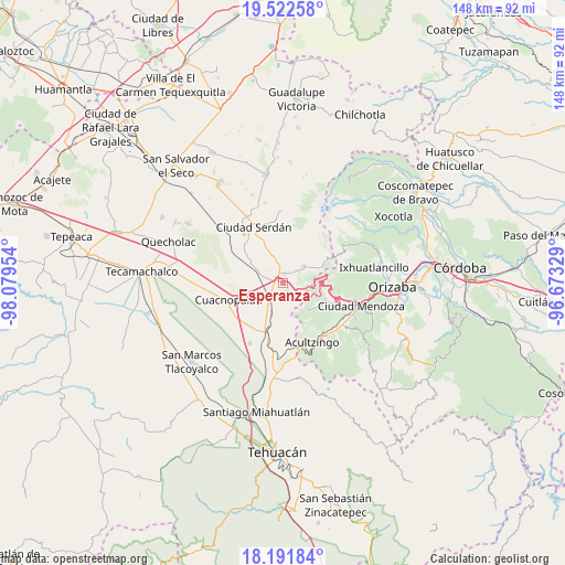
Esperanza GPS coordinates[2]
18° 51' 30.708" North, 97° 22' 35.076" West
| Map corner | latitude | longitude |
|---|---|---|
| Upper-left | 19.52258°, | -98.07954° |
| Center: | 18.85853°, | -97.37641° |
| Lower-right: | 18.19184°, | -96.67329° |
| Map W x H: | 148×148 km | = 92×92mi |
| max Lat: | 32.7° ⇑67.8% North |
| Esperanza: | 18.85853° |
| min Lat: | ⇓32.2% South 14.53588° |
| min Long | Esperanza | max Long |
| -117.105° | -97.37641° | -86.73105° |
| W 70.8%⇐ | ⇒29.2% E |
Elevation
Elevation of Esperanza is 2456 m = 8058 ft, and this is 1202.3 m = 3945 ft above average elevation for this country.
| Max E: |
3497 m = 11473 ft | 8.6% |
| Esperanza | 2456 m 8058 ft | |
| Avg. | 1253.7 m = 4113 ft | |
Min E: |
-1 m = -3 ft | 91.4% |
See also: Mexico elevation on elevation.city.
Geographical zone
Esperanza is located in North Torrid zone (between Equator and Tropic of Cancer). Distance of this Northern Tropic circle is 509 km =316.3 mi to North.| Distance of | km | miles | from Esperanza |
|---|---|---|---|
| North Pole | 7910.2 | 4915.2 | to North |
| Arctic Circle | 5304.3 | 3295.9 | to North |
| Tropic Cancer | 509 | 316.3 | to North |
| Equator | 2096.9 | 1303 | to South |


Nearby cities:
15 places around Esperanza: (largest is in red/bold)
• Amozoquillo Piletas
3.5 km =2.2 mi,  219°
219°
• Atzitzintla
7.1 km =4.4 mi,  50°
50°
• Barrio la Soledad
8 km =5 mi,  209°
209°
• Guadalupe Piletas
6.1 km =3.8 mi, 222°
• Los Garcías
6.4 km =4 mi,  196°
196°
• Los Ricardos
7.4 km =4.6 mi,  308°
308°
• Otilio Montaño
2.4 km =1.5 mi,  10°
10°
• Puerta Cañada
5.9 km =3.7 mi, 215°
• San Antonio Soledad
8.9 km =5.5 mi, 201°
• San Antonio de Abajo
3.5 km =2.2 mi,  25°
25°
• San José Cuyachapa
6.6 km =4.1 mi,  93°
93°
• Santa Catarina los Reyes
6.8 km =4.2 mi,  292°
292°
• Santa Cruz Cuyachapa
5.1 km =3.2 mi, 48°
• Tehuitzo
7.5 km =4.7 mi,  239°
239°
• Álvaro Obregón
7.2 km =4.5 mi, 314°
Sources, notices
• [Note1] Compared only with cities in Mexico existing in our database
• [Src1] Map data: © OpenStreetMap contributors (CC-BY-SA)
• [Src2] Other city data from geonames.org with taken over terms of usage.
• [Src3] Geographical zone / Annual Mean Temperature by Robert A. Rohde @ Wikipedia
