Álvaro Obregón geodata
Álvaro Obregón (Puebla) is a populated place; located in Mexico in America/Mexico_City (GMT-6) time zone. With population of 505 people, there are 16660 cities with bigger population in this country. Compared to other cities in Mexico, 66.9% of cities are located further ↑North; 70.3% of cities are located further ←West and 91.9% of cities have lower elevation than Álvaro Obregón. Note1


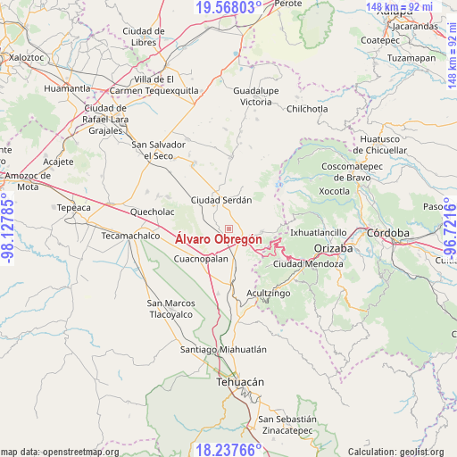
Álvaro Obregón GPS coordinates[2]
18° 54' 15.012" North, 97° 25' 28.992" West
| Map corner | latitude | longitude |
|---|---|---|
| Upper-left | 19.56803°, | -98.12785° |
| Center: | 18.90417°, | -97.42472° |
| Lower-right: | 18.23766°, | -96.7216° |
| Map W x H: | 147.9×147.9 km | = 91.9×91.9mi |
| max Lat: | 32.7° ⇑66.9% North |
| Álvaro Obregón: | 18.90417° |
| min Lat: | ⇓33.1% South 14.53588° |
| min Long | Álvaro Obregó | max Long |
| -117.105° | -97.42472° | -86.73105° |
| W 70.3%⇐ | ⇒29.7% E |
Elevation
Elevation of Álvaro Obregón is 2478 m = 8130 ft, and this is 1224.3 m = 4017 ft above average elevation for this country.
| Max E: |
3497 m = 11473 ft | 8.1% |
| Álvaro Obregón | 2478 m 8130 ft | |
| Avg. | 1253.7 m = 4113 ft | |
Min E: |
-1 m = -3 ft | 91.9% |
See also: Mexico elevation on elevation.city.
Geographical zone
Álvaro Obregón is located in North Torrid zone (between Equator and Tropic of Cancer). Distance of this Northern Tropic circle is 504 km =313.2 mi to North.| Distance of | km | miles | from Álvaro Obregón |
|---|---|---|---|
| North Pole | 7905.1 | 4912 | to North |
| Arctic Circle | 5299.2 | 3292.8 | to North |
| Tropic Cancer | 504 | 313.2 | to North |
| Equator | 2101.9 | 1306.1 | to South |


Nearby cities:
15 places around Álvaro Obregón: (largest is in red/bold)
• Amozoquillo Piletas
8.2 km =5.1 mi,  159°
159°
• Cuesta Blanca
7.9 km =4.9 mi,  214°
214°
• El Veladero
9.1 km =5.7 mi,  317°
317°
• Esperanza
7.2 km =4.5 mi,  134°
134°
• Guadalupe Piletas
9.6 km =6 mi,  174°
174°
• Jesús Nazareno (Rancho Nuevo)
3.5 km =2.2 mi,  273°
273°
• Las Palmas
9.4 km =5.8 mi,  289°
289°
• Los Ricardos
0.9 km =0.6 mi,  234°
234°
• Otilio Montaño
6.2 km =3.9 mi,  116°
116°
• San Antonio de Abajo
6.9 km =4.3 mi,  106°
106°
• San Pedro Temamatla
9.5 km =5.9 mi,  284°
284°
• Santa Catarina los Reyes
2.7 km =1.7 mi, 206°
• Santa Cruz Cuyachapa
9.1 km =5.7 mi,  100°
100°
• Santa María Techachalco
7.3 km =4.5 mi, 318°
• Tehuitzo
9 km =5.6 mi,  188°
188°
Sources, notices
• [Note1] Compared only with cities in Mexico existing in our database
• [Src1] Map data: © OpenStreetMap contributors (CC-BY-SA)
• [Src2] Other city data from geonames.org with taken over terms of usage.
• [Src3] Geographical zone / Annual Mean Temperature by Robert A. Rohde @ Wikipedia
