Guadalupe Piletas geodata
Guadalupe Piletas (Puebla) is a populated place; located in Mexico in America/Mexico_City (GMT-6) time zone. With population of 549 people, there are 15509 cities with bigger population in this country. Compared to other cities in Mexico, 68.4% of cities are located further ↑North; 70.4% of cities are located further ←West and 89% of cities have lower elevation than Guadalupe Piletas. Note1


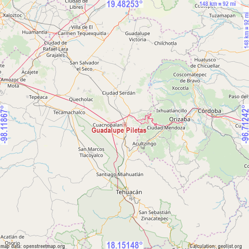
Guadalupe Piletas GPS coordinates[2]
18° 49' 5.952" North, 97° 24' 55.944" West
| Map corner | latitude | longitude |
|---|---|---|
| Upper-left | 19.48253°, | -98.11867° |
| Center: | 18.81832°, | -97.41554° |
| Lower-right: | 18.15148°, | -96.71242° |
| Map W x H: | 148×148 km | = 92×92mi |
| max Lat: | 32.7° ⇑68.4% North |
| Guadalupe Piletas: | 18.81832° |
| min Lat: | ⇓31.6% South 14.53588° |
| min Long | Guadalupe Pilet | max Long |
| -117.105° | -97.41554° | -86.73105° |
| W 70.4%⇐ | ⇒29.6% E |
Elevation
Elevation of Guadalupe Piletas is 2374 m = 7789 ft, and this is 1120.3 m = 3676 ft above average elevation for this country.
| Max E: |
3497 m = 11473 ft | 11% |
| Guadalupe Piletas | 2374 m 7789 ft | |
| Avg. | 1253.7 m = 4113 ft | |
Min E: |
-1 m = -3 ft | 89% |
See also: Mexico elevation on elevation.city.
Geographical zone
Guadalupe Piletas is located in North Torrid zone (between Equator and Tropic of Cancer). Distance of this Northern Tropic circle is 513.5 km =319.1 mi to North.| Distance of | km | miles | from Guadalupe Piletas |
|---|---|---|---|
| North Pole | 7914.7 | 4918 | to North |
| Arctic Circle | 5308.8 | 3298.7 | to North |
| Tropic Cancer | 513.5 | 319.1 | to North |
| Equator | 2092.4 | 1300.2 | to South |


Nearby cities:
15 places around Guadalupe Piletas: (largest is in red/bold)
• Amozoquillo Piletas
2.6 km =1.6 mi,  46°
46°
• Barrio la Soledad
2.5 km =1.6 mi,  175°
175°
• Buena Vista
9.2 km =5.7 mi,  153°
153°
• Cuesta Blanca
6.2 km =3.9 mi,  298°
298°
• Esperanza
6.1 km =3.8 mi,  42°
42°
• Guadalupe Fresnal
8.4 km =5.2 mi,  129°
129°
• Los Garcías
2.8 km =1.7 mi, 126°
• Morelos Cañada
9.2 km =5.7 mi, 183°
• Otilio Montaño
8.2 km =5.1 mi,  33°
33°
• Puerta Cañada
0.7 km =0.4 mi,  117°
117°
• San Antonio Soledad
3.9 km =2.4 mi,  167°
167°
• Santa Catarina los Reyes
7.4 km =4.6 mi,  342°
342°
• Tehuitzo
2.4 km =1.5 mi,  284°
284°
• Temaxcalapa
8.3 km =5.2 mi,  142°
142°
• Tezuapan (San Isidro)
6.2 km =3.9 mi, 169°
Sources, notices
• [Note1] Compared only with cities in Mexico existing in our database
• [Src1] Map data: © OpenStreetMap contributors (CC-BY-SA)
• [Src2] Other city data from geonames.org with taken over terms of usage.
• [Src3] Geographical zone / Annual Mean Temperature by Robert A. Rohde @ Wikipedia
