San José Cuyachapa geodata
San José Cuyachapa (Puebla) is a populated place; located in Mexico in America/Mexico_City (GMT-6) time zone. With population of 1,129 people, there are 7682 cities with bigger population in this country. Compared to other cities in Mexico, 67.9% of cities are located further ↑North; 71.4% of cities are located further ←West and 96% of cities have lower elevation than San José Cuyachapa. Note1


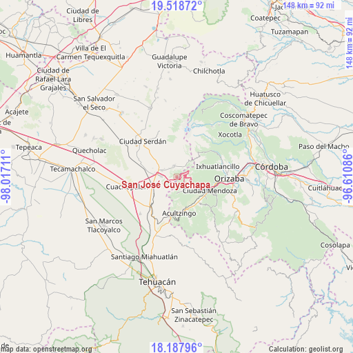
San José Cuyachapa GPS coordinates[2]
18° 51' 16.776" North, 97° 18' 50.328" West
| Map corner | latitude | longitude |
|---|---|---|
| Upper-left | 19.51872°, | -98.01711° |
| Center: | 18.85466°, | -97.31398° |
| Lower-right: | 18.18796°, | -96.61086° |
| Map W x H: | 148×148 km | = 92×92mi |
| max Lat: | 32.7° ⇑67.9% North |
| San José Cuyachapa: | 18.85466° |
| min Lat: | ⇓32.1% South 14.53588° |
| min Long | San José Cuyac | max Long |
| -117.105° | -97.31398° | -86.73105° |
| W 71.4%⇐ | ⇒28.6% E |
Elevation
Elevation of San José Cuyachapa is 2625 m = 8612 ft, and this is 1371.3 m = 4499 ft above average elevation for this country.
| Max E: |
3497 m = 11473 ft | 4% |
| San José Cuyachapa | 2625 m 8612 ft | |
| Avg. | 1253.7 m = 4113 ft | |
Min E: |
-1 m = -3 ft | 96% |
See also: Mexico elevation on elevation.city.
Geographical zone
San José Cuyachapa is located in North Torrid zone (between Equator and Tropic of Cancer). Distance of this Northern Tropic circle is 509.5 km =316.6 mi to North.| Distance of | km | miles | from San José Cuyachapa |
|---|---|---|---|
| North Pole | 7910.6 | 4915.4 | to North |
| Arctic Circle | 5304.7 | 3296.2 | to North |
| Tropic Cancer | 509.5 | 316.6 | to North |
| Equator | 2096.4 | 1302.6 | to South |


Nearby cities:
15 places around San José Cuyachapa: (largest is in red/bold)
• Amozoquillo Piletas
9.1 km =5.7 mi,  255°
255°
• Aquila
6.6 km =4.1 mi,  174°
174°
• Atzitzintla
5.1 km =3.2 mi,  347°
347°
• Cecilio Terán
10.3 km =6.4 mi,  115°
115°
• Esperanza
6.6 km =4.1 mi,  273°
273°
• Guadalupe Fresnal
10.3 km =6.4 mi,  203°
203°
• Los Garcías
10.2 km =6.3 mi,  235°
235°
• Maltrata
6.3 km =3.9 mi,  140°
140°
• Otilio Montaño
6.7 km =4.2 mi,  294°
294°
• Paso Carretas
9.8 km =6.1 mi,  42°
42°
• San Antonio de Abajo
6.2 km =3.9 mi,  305°
305°
• San José Súchil
8.9 km =5.5 mi,  65°
65°
• San Juan Huiloapan
5.7 km =3.5 mi, 38°
• Santa Cruz Cuyachapa
4.7 km =2.9 mi,  324°
324°
• Santa Cruz Texmalaquilla
10.2 km =6.3 mi,  15°
15°
Sources, notices
• [Note1] Compared only with cities in Mexico existing in our database
• [Src1] Map data: © OpenStreetMap contributors (CC-BY-SA)
• [Src2] Other city data from geonames.org with taken over terms of usage.
• [Src3] Geographical zone / Annual Mean Temperature by Robert A. Rohde @ Wikipedia
