Epazoyucan geodata
Epazoyucan (Hidalgo) is a seat of a second-order administrative division; located in Mexico in America/Mexico_City (GMT-6) time zone. With population of 3,168 people, there are 2853 cities with bigger population in this country. Compared to other cities in Mexico, 57.3% of cities are located further ↓South; 55.8% of cities are located further ←West and 91.7% of cities have lower elevation than Epazoyucan. Note1


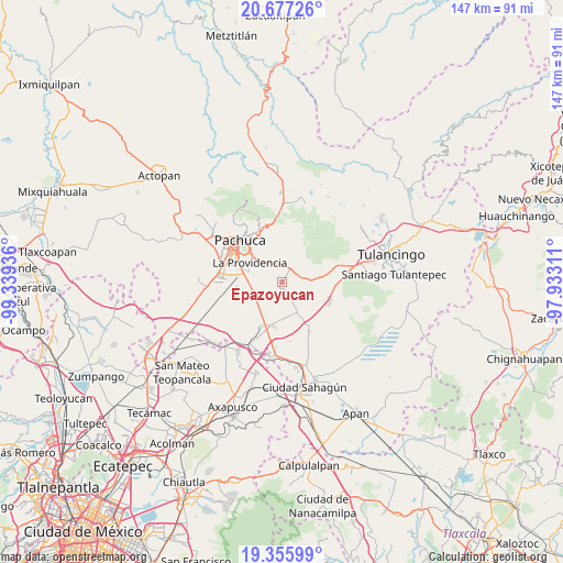
Epazoyucan GPS coordinates[2]
20° 1' 4.836" North, 98° 38' 10.428" West
| Map corner | latitude | longitude |
|---|---|---|
| Upper-left | 20.67726°, | -99.33936° |
| Center: | 20.01801°, | -98.63623° |
| Lower-right: | 19.35599°, | -97.93311° |
| Map W x H: | 146.9×146.9 km | = 91.3×91.3mi |
| max Lat: | 32.7° ⇑42.7% North |
| Epazoyucan: | 20.01801° |
| min Lat: | ⇓57.3% South 14.53588° |
| min Long | Epazoyucan | max Long |
| -117.105° | -98.63623° | -86.73105° |
| W 55.8%⇐ | ⇒44.2% E |
Elevation
Elevation of Epazoyucan is 2465 m = 8087 ft, and this is 1211.3 m = 3974 ft above average elevation for this country.
| Max E: |
3497 m = 11473 ft | 8.3% |
| Epazoyucan | 2465 m 8087 ft | |
| Avg. | 1253.7 m = 4113 ft | |
Min E: |
-1 m = -3 ft | 91.7% |
See also: Mexico elevation on elevation.city.
Geographical zone
Epazoyucan is located in North Torrid zone (between Equator and Tropic of Cancer). Distance of this Northern Tropic circle is 380.1 km =236.2 mi to North.| Distance of | km | miles | from Epazoyucan |
|---|---|---|---|
| North Pole | 7781.3 | 4835.1 | to North |
| Arctic Circle | 5175.4 | 3215.8 | to North |
| Tropic Cancer | 380.1 | 236.2 | to North |
| Equator | 2225.8 | 1383 | to South |


Nearby cities:
15 places around Epazoyucan: (largest is in red/bold)
• Francisco Villa
10.6 km =6.6 mi,  144°
144°
• La Providencia Siglo XXI
9.9 km =6.2 mi,  301°
301°
• La Trinidad
10 km =6.2 mi,  229°
229°
• Pachuquilla
8.6 km =5.3 mi,  313°
313°
• Rinconada de los Ángeles
7.9 km =4.9 mi,  276°
276°
• San Antonio Ostoyucan
10.3 km =6.4 mi,  197°
197°
• San Juan Tizahuapán
4.7 km =2.9 mi,  320°
320°
• San Miguel Nopalapa
8 km =5 mi,  268°
268°
• Santa Cruz
8.3 km =5.2 mi,  216°
216°
• Santa María Tecajete
9.8 km =6.1 mi,  153°
153°
• Santa María la Calera
8.8 km =5.5 mi, 279°
• Santa Mónica
4.1 km =2.5 mi,  157°
157°
• Villa Margarita
9.4 km =5.8 mi,  243°
243°
• Xochihuacán
8.4 km =5.2 mi,  246°
246°
• Xolostitla de Morelos (Xolostitla)
5.4 km =3.4 mi,  357°
357°
Sources, notices
• [Note1] Compared only with cities in Mexico existing in our database
• [Src1] Map data: © OpenStreetMap contributors (CC-BY-SA)
• [Src2] Other city data from geonames.org with taken over terms of usage.
• [Src3] Geographical zone / Annual Mean Temperature by Robert A. Rohde @ Wikipedia
