San Miguel Nopalapa geodata
San Miguel Nopalapa (Hidalgo) is a populated place; located in Mexico in America/Mexico_City (GMT-6) time zone. With population of 552 people, there are 15449 cities with bigger population in this country. Compared to other cities in Mexico, 57.3% of cities are located further ↓South; 54.9% of cities are located further ←West and 88.3% of cities have lower elevation than San Miguel Nopalapa. Note1


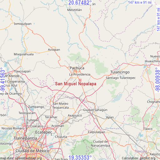
San Miguel Nopalapa GPS coordinates[2]
20° 0' 56.016" North, 98° 42' 45" West
| Map corner | latitude | longitude |
|---|---|---|
| Upper-left | 20.67482°, | -99.41563° |
| Center: | 20.01556°, | -98.7125° |
| Lower-right: | 19.35353°, | -98.00938° |
| Map W x H: | 146.9×146.9 km | = 91.3×91.3mi |
| max Lat: | 32.7° ⇑42.7% North |
| San Miguel Nopalapa: | 20.01556° |
| min Lat: | ⇓57.3% South 14.53588° |
| min Long | San Miguel Nopa | max Long |
| -117.105° | -98.7125° | -86.73105° |
| W 54.9%⇐ | ⇒45.1% E |
Elevation
Elevation of San Miguel Nopalapa is 2351 m = 7713 ft, and this is 1097.3 m = 3600 ft above average elevation for this country.
| Max E: |
3497 m = 11473 ft | 11.7% |
| San Miguel Nopalapa | 2351 m 7713 ft | |
| Avg. | 1253.7 m = 4113 ft | |
Min E: |
-1 m = -3 ft | 88.3% |
See also: Mexico elevation on elevation.city.
Geographical zone
San Miguel Nopalapa is located in North Torrid zone (between Equator and Tropic of Cancer). Distance of this Northern Tropic circle is 380.4 km =236.4 mi to North.| Distance of | km | miles | from San Miguel Nopalapa |
|---|---|---|---|
| North Pole | 7781.5 | 4835.2 | to North |
| Arctic Circle | 5175.7 | 3216 | to North |
| Tropic Cancer | 380.4 | 236.4 | to North |
| Equator | 2225.5 | 1382.9 | to South |


Nearby cities:
15 places around San Miguel Nopalapa: (largest is in red/bold)
• El Paraíso
6 km =3.7 mi,  329°
329°
• El Roble
6.7 km =4.2 mi,  314°
314°
• El Saucillo (Fraccionamiento)
6.2 km =3.9 mi,  340°
340°
• La Providencia Siglo XXI
5.4 km =3.4 mi,  354°
354°
• La Trinidad
6.2 km =3.9 mi,  177°
177°
• Las Flores
6.5 km =4 mi, 305°
• Los Tuzos
6.3 km =3.9 mi, 312°
• Nuevo Centro de Población Agrícola el Chacón
6.7 km =4.2 mi, 335°
• Pachuquilla
6.4 km =4 mi,  15°
15°
• Rinconada de los Ángeles
1.2 km =0.7 mi,  5°
5°
• San José Palma Gorda
4.1 km =2.5 mi,  280°
280°
• San Juan Tizahuapán
6.3 km =3.9 mi,  51°
51°
• Santa María la Calera
1.8 km =1.1 mi, 337°
• Villa Margarita
3.9 km =2.4 mi,  186°
186°
• Xochihuacán
3.2 km =2 mi,  174°
174°
Sources, notices
• [Note1] Compared only with cities in Mexico existing in our database
• [Src1] Map data: © OpenStreetMap contributors (CC-BY-SA)
• [Src2] Other city data from geonames.org with taken over terms of usage.
• [Src3] Geographical zone / Annual Mean Temperature by Robert A. Rohde @ Wikipedia
