El Sauce (Cerro Grande) geodata
El Sauce (Cerro Grande) (Veracruz) is a populated place; located in Mexico in America/Mexico_City (GMT-6) time zone. With population of 794 people, there are 10982 cities with bigger population in this country. Compared to other cities in Mexico, 70.1% of cities are located further ↑North; 82% of cities are located further ←West and 92.1% of cities have higher elevation than El Sauce (Cerro Grande). Note1
Current local time in El Sauce (Cerro Grande):
07:25 AM, MondayDifference from your time zone: hours


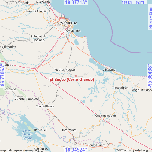
El Sauce (Cerro Grande) GPS coordinates[2]
18° 42' 45" North, 96° 4' 3" West
| Map corner | latitude | longitude |
|---|---|---|
| Upper-left | 19.37713°, | -96.77063° |
| Center: | 18.7125°, | -96.0675° |
| Lower-right: | 18.04524°, | -95.36438° |
| Map W x H: | 148.1×148.1 km | = 92×92mi |
| max Lat: | 32.7° ⇑70.1% North |
| El Sauce (Cerro Grande): | 18.7125° |
| min Lat: | ⇓29.9% South 14.53588° |
| min Long | El Sauce (Cerro | max Long |
| -117.105° | -96.0675° | -86.73105° |
| W 82%⇐ | ⇒18% E |
Elevation
Elevation of El Sauce (Cerro Grande) is 19 m = 62 ft, and this is 1234.7 m = 4051 ft below average elevation for this country.
| Max E: |
3497 m = 11473 ft | 92.1% |
| Avg. | 1253.7 m = 4113 ft | |
| El Sauce (Cerro Grande) | 19 m = 62 ft | |
Min E: |
-1 m = -3 ft | 7.9% |
See also: Mexico elevation on elevation.city.
Geographical zone
El Sauce (Cerro Grande) is located in North Torrid zone (between Equator and Tropic of Cancer). Distance of this Northern Tropic circle is 525.3 km =326.4 mi to North.| Distance of | km | miles | from El Sauce (Cerro Grande) |
|---|---|---|---|
| North Pole | 7926.4 | 4925.2 | to North |
| Arctic Circle | 5320.5 | 3306 | to North |
| Tropic Cancer | 525.3 | 326.4 | to North |
| Equator | 2080.6 | 1292.8 | to South |


Nearby cities:
15 places around El Sauce (Cerro Grande): (largest is in red/bold)
• El Cocuite
1.9 km =1.2 mi,  287°
287°
• El Ojochal
2.4 km =1.5 mi,  94°
94°
• El Salitral
10 km =6.2 mi,  128°
128°
• El Salto
7.3 km =4.5 mi,  156°
156°
• El Zapote
8.7 km =5.4 mi,  316°
316°
• El Zapote
11.5 km =7.1 mi,  76°
76°
• Ignacio de la Llave
8.6 km =5.3 mi, 80°
• Moyotla
5.7 km =3.5 mi, 79°
• Palma Cuata
5.7 km =3.5 mi,  113°
113°
• Paso Carretas
8 km =5 mi,  247°
247°
• Tlalixcoyan
10 km =6.2 mi,  4°
4°
• Tuzales
8.3 km =5.2 mi,  336°
336°
• Villanueva
8.6 km =5.3 mi, 105°
• Zacate Colorado Primero (El Moral)
9.3 km =5.8 mi,  121°
121°
• Zacate Colorado Segundo (Fraternidad)
10.7 km =6.6 mi, 107°
Sources, notices
• [Note1] Compared only with cities in Mexico existing in our database
• [Src1] Map data: © OpenStreetMap contributors (CC-BY-SA)
• [Src2] Other city data from geonames.org with taken over terms of usage.
• [Src3] Geographical zone / Annual Mean Temperature by Robert A. Rohde @ Wikipedia
