Tuzales geodata
Tuzales (Veracruz) is a populated place; located in Mexico in America/Mexico_City (GMT-6) time zone. With population of 872 people, there are 10017 cities with bigger population in this country. Compared to other cities in Mexico, 69% of cities are located further ↑North; 81.8% of cities are located further ←West and 93.5% of cities have higher elevation than Tuzales. Note1


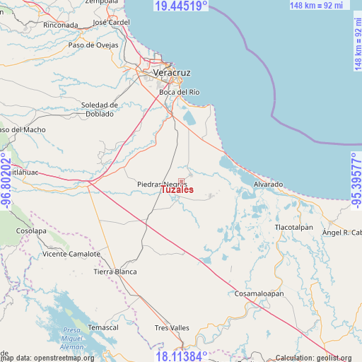
Tuzales GPS coordinates[2]
18° 46' 50.988" North, 96° 5' 56.004" West
| Map corner | latitude | longitude |
|---|---|---|
| Upper-left | 19.44519°, | -96.80202° |
| Center: | 18.78083°, | -96.09889° |
| Lower-right: | 18.11384°, | -95.39577° |
| Map W x H: | 148×148 km | = 92×92mi |
| max Lat: | 32.7° ⇑69% North |
| Tuzales: | 18.78083° |
| min Lat: | ⇓31% South 14.53588° |
| min Long | Tuzales | max Long |
| -117.105° | -96.09889° | -86.73105° |
| W 81.8%⇐ | ⇒18.2% E |
Elevation
Elevation of Tuzales is 16 m = 52 ft, and this is 1237.7 m = 4061 ft below average elevation for this country.
| Max E: |
3497 m = 11473 ft | 93.5% |
| Avg. | 1253.7 m = 4113 ft | |
| Tuzales | 16 m = 52 ft | |
Min E: |
-1 m = -3 ft | 6.5% |
See also: Mexico elevation on elevation.city.
Geographical zone
Tuzales is located in North Torrid zone (between Equator and Tropic of Cancer). Distance of this Northern Tropic circle is 517.7 km =321.7 mi to North.| Distance of | km | miles | from Tuzales |
|---|---|---|---|
| North Pole | 7918.8 | 4920.5 | to North |
| Arctic Circle | 5312.9 | 3301.3 | to North |
| Tropic Cancer | 517.7 | 321.7 | to North |
| Equator | 2088.2 | 1297.5 | to South |


Nearby cities:
15 places around Tuzales: (largest is in red/bold)
• El Cocuite
7.2 km =4.5 mi,  167°
167°
• El Ojochal
9.6 km =6 mi,  143°
143°
• El Sauce (Cerro Grande)
8.3 km =5.2 mi,  156°
156°
• El Zapote
3 km =1.9 mi,  243°
243°
• Ignacio de la Llave
13.3 km =8.3 mi,  117°
117°
• Mata Cabestro (La Víbora)
15.2 km =9.4 mi,  11°
11°
• Mata de Lázaro
14.1 km =8.8 mi,  263°
263°
• Moyotla
11 km =6.8 mi,  126°
126°
• Palma Cuata
13.1 km =8.1 mi, 139°
• Paloma Sola
9.9 km =6.2 mi,  17°
17°
• Paso Carretas
11.5 km =7.1 mi,  200°
200°
• Piedras Negras
7.8 km =4.8 mi, 261°
• Pozuelo
5.8 km =3.6 mi, 24°
• Tlalixcoyan
4.7 km =2.9 mi,  59°
59°
• Villanueva
15.2 km =9.4 mi, 130°
Sources, notices
• [Note1] Compared only with cities in Mexico existing in our database
• [Src1] Map data: © OpenStreetMap contributors (CC-BY-SA)
• [Src2] Other city data from geonames.org with taken over terms of usage.
• [Src3] Geographical zone / Annual Mean Temperature by Robert A. Rohde @ Wikipedia
