El Salitral geodata
El Salitral (Veracruz) is a populated place; located in Mexico in America/Mexico_City (GMT-6) time zone. With population of 755 people, there are 11595 cities with bigger population in this country. Compared to other cities in Mexico, 70.7% of cities are located further ↑North; 82.2% of cities are located further ←West and 98.1% of cities have higher elevation than El Salitral. Note1


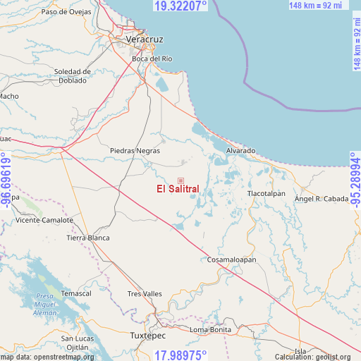
El Salitral GPS coordinates[2]
18° 39' 25.992" North, 95° 59' 35.016" West
| Map corner | latitude | longitude |
|---|---|---|
| Upper-left | 19.32207°, | -96.69619° |
| Center: | 18.65722°, | -95.99306° |
| Lower-right: | 17.98975°, | -95.28994° |
| Map W x H: | 148.1×148.1 km | = 92×92mi |
| max Lat: | 32.7° ⇑70.7% North |
| El Salitral: | 18.65722° |
| min Lat: | ⇓29.3% South 14.53588° |
| min Long | El Salitral | max Long |
| -117.105° | -95.99306° | -86.73105° |
| W 82.2%⇐ | ⇒17.8% E |
Elevation
Elevation of El Salitral is 8 m = 26 ft, and this is 1245.7 m = 4087 ft below average elevation for this country.
| Max E: |
3497 m = 11473 ft | 98.1% |
| Avg. | 1253.7 m = 4113 ft | |
| El Salitral | 8 m = 26 ft | |
Min E: |
-1 m = -3 ft | 1.9% |
See also: Mexico elevation on elevation.city.
Geographical zone
El Salitral is located in North Torrid zone (between Equator and Tropic of Cancer). Distance of this Northern Tropic circle is 531.4 km =330.2 mi to North.| Distance of | km | miles | from El Salitral |
|---|---|---|---|
| North Pole | 7932.6 | 4929.1 | to North |
| Arctic Circle | 5326.7 | 3309.9 | to North |
| Tropic Cancer | 531.4 | 330.2 | to North |
| Equator | 2074.5 | 1289 | to South |


Nearby cities:
15 places around El Salitral: (largest is in red/bold)
• El Cocuite
11.7 km =7.3 mi,  304°
304°
• El Moral
15.2 km =9.4 mi,  229°
229°
• El Ojochal
8.1 km =5 mi,  317°
317°
• El Salto
4.9 km =3 mi,  263°
263°
• El Sauce (Cerro Grande)
10 km =6.2 mi,  308°
308°
• El Zapote
9.4 km =5.8 mi,  20°
20°
• Ignacio de la Llave
7.7 km =4.8 mi,  4°
4°
• La Isla
17.7 km =11 mi,  248°
248°
• Moyotla
7.5 km =4.7 mi,  342°
342°
• Palma Cuata
4.7 km =2.9 mi,  326°
326°
• Paso Carretas
15.5 km =9.6 mi,  281°
281°
• Tlalixcoyan
17.6 km =10.9 mi, 336°
• Villanueva
3.9 km =2.4 mi,  6°
6°
• Zacate Colorado Primero (El Moral)
1.3 km =0.8 mi, 1°
• Zacate Colorado Segundo (Fraternidad)
3.7 km =2.3 mi,  38°
38°
Sources, notices
• [Note1] Compared only with cities in Mexico existing in our database
• [Src1] Map data: © OpenStreetMap contributors (CC-BY-SA)
• [Src2] Other city data from geonames.org with taken over terms of usage.
• [Src3] Geographical zone / Annual Mean Temperature by Robert A. Rohde @ Wikipedia
