El Laurel geodata
El Laurel (Veracruz) is a populated place; located in Mexico in America/Mexico_City (GMT-6) time zone. With population of 1,470 people, there are 5880 cities with bigger population in this country. Compared to other cities in Mexico, 75.2% of cities are located further ↑North; 83.5% of cities are located further ←West and 88.6% of cities have higher elevation than El Laurel. Note1


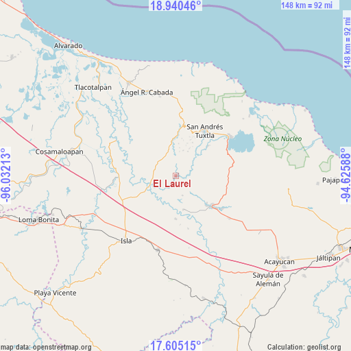
El Laurel GPS coordinates[2]
18° 16' 26.724" North, 95° 19' 44.4" West
| Map corner | latitude | longitude |
|---|---|---|
| Upper-left | 18.94046°, | -96.03213° |
| Center: | 18.27409°, | -95.329° |
| Lower-right: | 17.60515°, | -94.62588° |
| Map W x H: | 148.5×148.5 km | = 92.3×92.3mi |
| max Lat: | 32.7° ⇑75.2% North |
| El Laurel: | 18.27409° |
| min Lat: | ⇓24.8% South 14.53588° |
| min Long | El Laurel | max Long |
| -117.105° | -95.329° | -86.73105° |
| W 83.5%⇐ | ⇒16.5% E |
Elevation
Elevation of El Laurel is 28 m = 92 ft, and this is 1225.7 m = 4021 ft below average elevation for this country.
| Max E: |
3497 m = 11473 ft | 88.6% |
| Avg. | 1253.7 m = 4113 ft | |
| El Laurel | 28 m = 92 ft | |
Min E: |
-1 m = -3 ft | 11.4% |
See also: Mexico elevation on elevation.city.
Geographical zone
El Laurel is located in North Torrid zone (between Equator and Tropic of Cancer). Distance of this Northern Tropic circle is 574 km =356.7 mi to North.| Distance of | km | miles | from El Laurel |
|---|---|---|---|
| North Pole | 7975.2 | 4955.6 | to North |
| Arctic Circle | 5369.3 | 3336.3 | to North |
| Tropic Cancer | 574 | 356.7 | to North |
| Equator | 2031.9 | 1262.6 | to South |


Nearby cities:
15 places around El Laurel: (largest is in red/bold)
• Apixita
6 km =3.7 mi,  39°
39°
• El Platanar
6.1 km =3.8 mi,  348°
348°
• El Popotal
4.1 km =2.5 mi,  139°
139°
• El Remolino
7.4 km =4.6 mi,  70°
70°
• El Zapotal
6.5 km =4 mi,  277°
277°
• Francisco I. Madero
6.8 km =4.2 mi,  328°
328°
• Galeras
10.9 km =6.8 mi,  251°
251°
• Juan Jacobo Torres [Bodega de Totontepec]
10 km =6.2 mi,  46°
46°
• La Redonda
6.7 km =4.2 mi,  29°
29°
• Mazumiapam
3.7 km =2.3 mi,  357°
357°
• Norma
8.6 km =5.3 mi,  161°
161°
• Rincón de Zapatero
10.9 km =6.8 mi,  341°
341°
• Río de Tuxtla
1.5 km =0.9 mi,  55°
55°
• Tibernal
9.7 km =6 mi,  305°
305°
• Tilapan
8.3 km =5.2 mi,  0°
0°
Sources, notices
• [Note1] Compared only with cities in Mexico existing in our database
• [Src1] Map data: © OpenStreetMap contributors (CC-BY-SA)
• [Src2] Other city data from geonames.org with taken over terms of usage.
• [Src3] Geographical zone / Annual Mean Temperature by Robert A. Rohde @ Wikipedia
