Apixita geodata
Apixita (Veracruz) is a populated place; located in Mexico in America/Mexico_City (GMT-6) time zone. With population of 601 people, there are 14318 cities with bigger population in this country. Compared to other cities in Mexico, 74.7% of cities are located further ↑North; 83.6% of cities are located further ←West and 83.1% of cities have higher elevation than Apixita. Note1


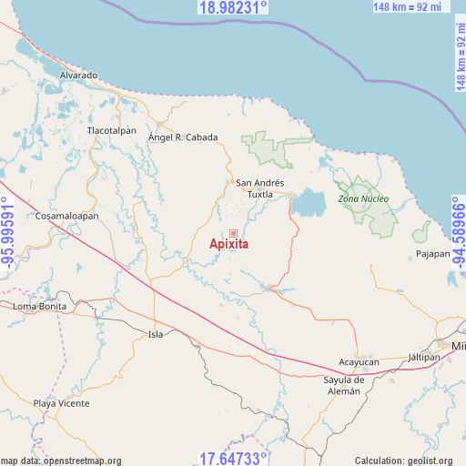
Apixita GPS coordinates[2]
18° 18' 57.996" North, 95° 17' 34.008" West
| Map corner | latitude | longitude |
|---|---|---|
| Upper-left | 18.98231°, | -95.99591° |
| Center: | 18.31611°, | -95.29278° |
| Lower-right: | 17.64733°, | -94.58966° |
| Map W x H: | 148.4×148.4 km | = 92.2×92.2mi |
| max Lat: | 32.7° ⇑74.7% North |
| Apixita: | 18.31611° |
| min Lat: | ⇓25.3% South 14.53588° |
| min Long | Apixita | max Long |
| -117.105° | -95.29278° | -86.73105° |
| W 83.6%⇐ | ⇒16.4% E |
Elevation
Elevation of Apixita is 59 m = 194 ft, and this is 1194.7 m = 3920 ft below average elevation for this country.
| Max E: |
3497 m = 11473 ft | 83.1% |
| Avg. | 1253.7 m = 4113 ft | |
| Apixita | 59 m = 194 ft | |
Min E: |
-1 m = -3 ft | 16.9% |
See also: Mexico elevation on elevation.city.
Geographical zone
Apixita is located in North Torrid zone (between Equator and Tropic of Cancer). Distance of this Northern Tropic circle is 569.4 km =353.8 mi to North.| Distance of | km | miles | from Apixita |
|---|---|---|---|
| North Pole | 7970.5 | 4952.6 | to North |
| Arctic Circle | 5364.6 | 3333.4 | to North |
| Tropic Cancer | 569.4 | 353.8 | to North |
| Equator | 2036.6 | 1265.5 | to South |


Nearby cities:
15 places around Apixita: (largest is in red/bold)
• Axochío
6.2 km =3.9 mi,  353°
353°
• Cuesta Amarilla
7.1 km =4.4 mi,  61°
61°
• El Laurel
6 km =3.7 mi,  219°
219°
• El Platanar
5.2 km =3.2 mi,  284°
284°
• El Remolino
3.8 km =2.4 mi,  125°
125°
• Francisco I. Madero
7.5 km =4.7 mi, 279°
• Juan Jacobo Torres [Bodega de Totontepec]
4.1 km =2.5 mi, 56°
• La Redonda
1.3 km =0.8 mi,  338°
338°
• Los Mérida
7.3 km =4.5 mi,  14°
14°
• Los Naranjos
5.6 km =3.5 mi,  72°
72°
• Mazumiapam
4.1 km =2.5 mi,  256°
256°
• Río de Tuxtla
4.6 km =2.9 mi,  213°
213°
• Soyata
6 km =3.7 mi, 10°
• Tilapan
5.2 km =3.2 mi,  314°
314°
• Tulapam
7 km =4.3 mi,  91°
91°
Sources, notices
• [Note1] Compared only with cities in Mexico existing in our database
• [Src1] Map data: © OpenStreetMap contributors (CC-BY-SA)
• [Src2] Other city data from geonames.org with taken over terms of usage.
• [Src3] Geographical zone / Annual Mean Temperature by Robert A. Rohde @ Wikipedia
