Norma geodata
Norma (Veracruz) is a populated place; located in Mexico in America/Mexico_City (GMT-6) time zone. With population of 901 people, there are 9681 cities with bigger population in this country. Compared to other cities in Mexico, 76.2% of cities are located further ↑North; 83.6% of cities are located further ←West and 89.7% of cities have higher elevation than Norma. Note1


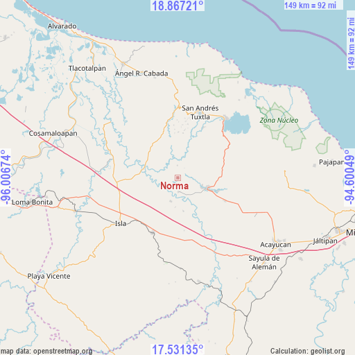
Norma GPS coordinates[2]
18° 12' 2.016" North, 95° 18' 12.996" West
| Map corner | latitude | longitude |
|---|---|---|
| Upper-left | 18.86721°, | -96.00674° |
| Center: | 18.20056°, | -95.30361° |
| Lower-right: | 17.53135°, | -94.60049° |
| Map W x H: | 148.5×148.5 km | = 92.3×92.3mi |
| max Lat: | 32.7° ⇑76.2% North |
| Norma: | 18.20056° |
| min Lat: | ⇓23.8% South 14.53588° |
| min Long | Norma | max Long |
| -117.105° | -95.30361° | -86.73105° |
| W 83.6%⇐ | ⇒16.4% E |
Elevation
Elevation of Norma is 25 m = 82 ft, and this is 1228.7 m = 4031 ft below average elevation for this country.
| Max E: |
3497 m = 11473 ft | 89.7% |
| Avg. | 1253.7 m = 4113 ft | |
| Norma | 25 m = 82 ft | |
Min E: |
-1 m = -3 ft | 10.3% |
See also: Mexico elevation on elevation.city.
Geographical zone
Norma is located in North Torrid zone (between Equator and Tropic of Cancer). Distance of this Northern Tropic circle is 582.2 km =361.8 mi to North.| Distance of | km | miles | from Norma |
|---|---|---|---|
| North Pole | 7983.3 | 4960.6 | to North |
| Arctic Circle | 5377.5 | 3341.4 | to North |
| Tropic Cancer | 582.2 | 361.8 | to North |
| Equator | 2023.7 | 1257.5 | to South |


Nearby cities:
15 places around Norma: (largest is in red/bold)
• Abrevadero
13.1 km =8.1 mi,  46°
46°
• Apixita
12.9 km =8 mi,  5°
5°
• Cuatotolapan Viejo
7.2 km =4.5 mi,  146°
146°
• El Laurel
8.6 km =5.3 mi,  341°
341°
• El Popotal
5.1 km =3.2 mi,  359°
359°
• El Remolino
11.4 km =7.1 mi,  21°
21°
• El Sauzal
8.8 km =5.5 mi,  102°
102°
• El Zapotal
12.8 km =8 mi,  314°
314°
• La Cañada
12.4 km =7.7 mi,  184°
184°
• La Gloria
10.8 km =6.7 mi,  107°
107°
• Mazumiapam
12.2 km =7.6 mi,  346°
346°
• Nopalapan
10.2 km =6.3 mi,  196°
196°
• Río de Tuxtla
9.2 km =5.7 mi, 351°
• Santa Catalina
10.9 km =6.8 mi, 112°
• Zapoapan de Amapan
13.2 km =8.2 mi,  71°
71°
Sources, notices
• [Note1] Compared only with cities in Mexico existing in our database
• [Src1] Map data: © OpenStreetMap contributors (CC-BY-SA)
• [Src2] Other city data from geonames.org with taken over terms of usage.
• [Src3] Geographical zone / Annual Mean Temperature by Robert A. Rohde @ Wikipedia
