El Platanar geodata
El Platanar (Veracruz) is a populated place; located in Mexico in America/Mexico_City (GMT-6) time zone. With population of 571 people, there are 14980 cities with bigger population in this country. Compared to other cities in Mexico, 74.6% of cities are located further ↑North; 83.5% of cities are located further ←West and 85.5% of cities have higher elevation than El Platanar. Note1


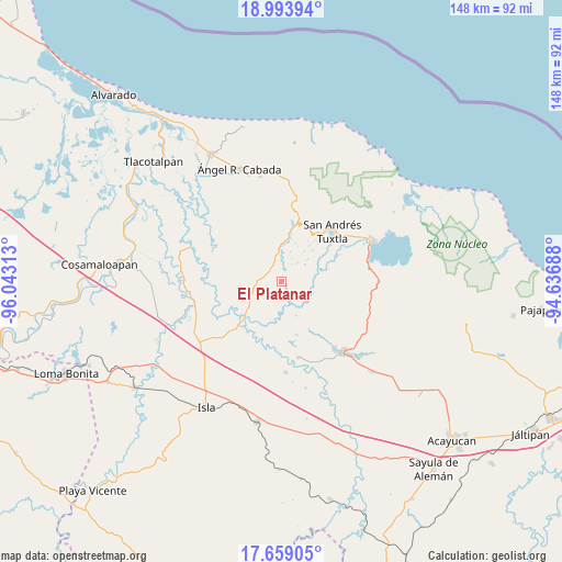
El Platanar GPS coordinates[2]
18° 19' 40.008" North, 95° 20' 24" West
| Map corner | latitude | longitude |
|---|---|---|
| Upper-left | 18.99394°, | -96.04313° |
| Center: | 18.32778°, | -95.34° |
| Lower-right: | 17.65905°, | -94.63688° |
| Map W x H: | 148.4×148.4 km | = 92.2×92.2mi |
| max Lat: | 32.7° ⇑74.6% North |
| El Platanar: | 18.32778° |
| min Lat: | ⇓25.4% South 14.53588° |
| min Long | El Platanar | max Long |
| -117.105° | -95.34° | -86.73105° |
| W 83.5%⇐ | ⇒16.5% E |
Elevation
Elevation of El Platanar is 41 m = 135 ft, and this is 1212.7 m = 3979 ft below average elevation for this country.
| Max E: |
3497 m = 11473 ft | 85.5% |
| Avg. | 1253.7 m = 4113 ft | |
| El Platanar | 41 m = 135 ft | |
Min E: |
-1 m = -3 ft | 14.5% |
See also: Mexico elevation on elevation.city.
Geographical zone
El Platanar is located in North Torrid zone (between Equator and Tropic of Cancer). Distance of this Northern Tropic circle is 568.1 km =353 mi to North.| Distance of | km | miles | from El Platanar |
|---|---|---|---|
| North Pole | 7969.2 | 4951.8 | to North |
| Arctic Circle | 5363.3 | 3332.6 | to North |
| Tropic Cancer | 568.1 | 353 | to North |
| Equator | 2037.9 | 1266.3 | to South |


Nearby cities:
15 places around El Platanar: (largest is in red/bold)
• Apixita
5.2 km =3.2 mi,  104°
104°
• Axochío
6.5 km =4 mi,  40°
40°
• Boca del Monte
7.5 km =4.7 mi,  329°
329°
• El Laurel
6.1 km =3.8 mi,  168°
168°
• El Zapotal
7.4 km =4.6 mi,  225°
225°
• Francisco I. Madero
2.4 km =1.5 mi,  267°
267°
• La Redonda
4.5 km =2.8 mi,  91°
91°
• Mazumiapam
2.5 km =1.6 mi,  155°
155°
• Ojo de Agua
5.9 km =3.7 mi, 329°
• Rincón de Zapatero
4.9 km =3 mi, 331°
• Río de Tuxtla
5.6 km =3.5 mi,  154°
154°
• San Leopoldo
6.6 km =4.1 mi,  23°
23°
• Soyata
7.6 km =4.7 mi,  53°
53°
• Tibernal
6.7 km =4.2 mi, 267°
• Tilapan
2.7 km =1.7 mi,  27°
27°
Sources, notices
• [Note1] Compared only with cities in Mexico existing in our database
• [Src1] Map data: © OpenStreetMap contributors (CC-BY-SA)
• [Src2] Other city data from geonames.org with taken over terms of usage.
• [Src3] Geographical zone / Annual Mean Temperature by Robert A. Rohde @ Wikipedia
