Tasquillo geodata
Tasquillo (Hidalgo) is a populated place; located in Mexico in America/Mexico_City (GMT-6) time zone. With population of 3,744 people, there are 2451 cities with bigger population in this country. Compared to other cities in Mexico, 68.8% of cities are located further ↓South; 54.3% of cities are located further →East and 56.7% of cities have lower elevation than Tasquillo. Note1


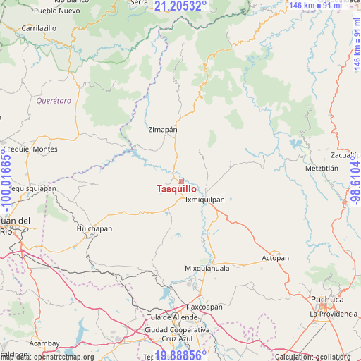
Tasquillo GPS coordinates[2]
20° 32' 54.096" North, 99° 18' 48.672" West
| Map corner | latitude | longitude |
|---|---|---|
| Upper-left | 21.20532°, | -100.01665° |
| Center: | 20.54836°, | -99.31352° |
| Lower-right: | 19.88856°, | -98.6104° |
| Map W x H: | 146.4×146.4 km | = 91×91mi |
| max Lat: | 32.7° ⇑31.2% North |
| Tasquillo: | 20.54836° |
| min Lat: | ⇓68.8% South 14.53588° |
| min Long | Tasquillo | max Long |
| -117.105° | -99.31352° | -86.73105° |
| W 45.7%⇐ | ⇒54.3% E |
Elevation
Elevation of Tasquillo is 1649 m = 5410 ft, and this is 395.3 m = 1297 ft above average elevation for this country.
| Max E: |
3497 m = 11473 ft | 43.3% |
| Tasquillo | 1649 m 5410 ft | |
| Avg. | 1253.7 m = 4113 ft | |
Min E: |
-1 m = -3 ft | 56.7% |
See also: Mexico elevation on elevation.city.
Geographical zone
Tasquillo is located in North Torrid zone (between Equator and Tropic of Cancer). Distance of this Northern Tropic circle is 321.2 km =199.6 mi to North.| Distance of | km | miles | from Tasquillo |
|---|---|---|---|
| North Pole | 7722.3 | 4798.4 | to North |
| Arctic Circle | 5116.4 | 3179.2 | to North |
| Tropic Cancer | 321.2 | 199.6 | to North |
| Equator | 2284.8 | 1419.7 | to South |


Nearby cities:
15 places around Tasquillo: (largest is in red/bold)
• Arbolado
2 km =1.2 mi,  325°
325°
• Bondhí
2.6 km =1.6 mi,  133°
133°
• Caltimacan
6 km =3.7 mi,  257°
257°
• Danghu
5.9 km =3.7 mi,  217°
217°
• El Deca
8.7 km =5.4 mi,  155°
155°
• El Déxtho
6.8 km =4.2 mi,  136°
136°
• Ignacio López Rayón
8.3 km =5.2 mi,  147°
147°
• Juchitlán
2.7 km =1.7 mi,  90°
90°
• La Candelaria
2 km =1.2 mi,  14°
14°
• La Heredad
9.4 km =5.8 mi,  114°
114°
• La Vega
6.5 km =4 mi,  194°
194°
• Portezuelo
6.9 km =4.3 mi,  173°
173°
• San Isidro
1.1 km =0.7 mi, 256°
• San Juanico
7.5 km =4.7 mi,  102°
102°
• Santiago Ixtlahuaca
5.6 km =3.5 mi, 188°
Sources, notices
• [Note1] Compared only with cities in Mexico existing in our database
• [Src1] Map data: © OpenStreetMap contributors (CC-BY-SA)
• [Src2] Other city data from geonames.org with taken over terms of usage.
• [Src3] Geographical zone / Annual Mean Temperature by Robert A. Rohde @ Wikipedia
