Copanatoyac geodata
Copanatoyac (Guerrero) is a seat of a second-order administrative division; located in Mexico in America/Mexico_City (GMT-6) time zone. With population of 2,924 people, there are 3047 cities with bigger population in this country. Compared to other cities in Mexico, 83.5% of cities are located further ↑North; 54.9% of cities are located further ←West and 51.1% of cities have higher elevation than Copanatoyac. Note1


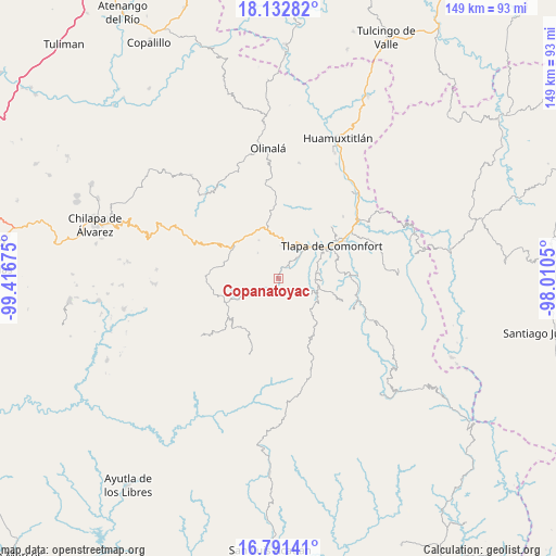
Copanatoyac GPS coordinates[2]
17° 27' 48.06" North, 98° 42' 49.032" West
| Map corner | latitude | longitude |
|---|---|---|
| Upper-left | 18.13282°, | -99.41675° |
| Center: | 17.46335°, | -98.71362° |
| Lower-right: | 16.79141°, | -98.0105° |
| Map W x H: | 149.2×149.2 km | = 92.7×92.7mi |
| max Lat: | 32.7° ⇑83.5% North |
| Copanatoyac: | 17.46335° |
| min Lat: | ⇓16.5% South 14.53588° |
| min Long | Copanatoyac | max Long |
| -117.105° | -98.71362° | -86.73105° |
| W 54.9%⇐ | ⇒45.1% E |
Elevation
Elevation of Copanatoyac is 1377 m = 4518 ft, and this is 123.3 m = 405 ft above average elevation for this country.
| Max E: |
3497 m = 11473 ft | 51.1% |
| Copanatoyac | 1377 m 4518 ft | |
| Avg. | 1253.7 m = 4113 ft | |
Min E: |
-1 m = -3 ft | 48.9% |
See also: Mexico elevation on elevation.city.
Geographical zone
Copanatoyac is located in North Torrid zone (between Equator and Tropic of Cancer). Distance of this Northern Tropic circle is 664.2 km =412.7 mi to North.| Distance of | km | miles | from Copanatoyac |
|---|---|---|---|
| North Pole | 8065.3 | 5011.5 | to North |
| Arctic Circle | 5459.4 | 3392.3 | to North |
| Tropic Cancer | 664.2 | 412.7 | to North |
| Equator | 1941.7 | 1206.5 | to South |


Nearby cities:
15 places around Copanatoyac: (largest is in red/bold)
• Aquilpa
9 km =5.6 mi,  3°
3°
• Atlamajalcingo del Río
9.4 km =5.8 mi,  41°
41°
• Cacahuatepec
8.9 km =5.5 mi,  320°
320°
• Colonia la Reforma
4.4 km =2.7 mi,  185°
185°
• Huiztlatzala
9.8 km =6.1 mi,  217°
217°
• Ocoapa
9.6 km =6 mi,  156°
156°
• Ocotequila
4.1 km =2.5 mi,  111°
111°
• Oztocingo
4.8 km =3 mi,  51°
51°
• Patlicha
2.8 km =1.7 mi,  197°
197°
• Potoichán
4.6 km =2.9 mi, 187°
• San Pedro Huitzapula Norte (Huitzapula Norte)
10.6 km =6.6 mi,  247°
247°
• Santa Anita
4.2 km =2.6 mi, 187°
• Tlalquetzalapa
4 km =2.5 mi,  350°
350°
• Tlaquilzingo
10.4 km =6.5 mi,  62°
62°
• Zapotitlán Tablas
8.3 km =5.2 mi,  238°
238°
Sources, notices
• [Note1] Compared only with cities in Mexico existing in our database
• [Src1] Map data: © OpenStreetMap contributors (CC-BY-SA)
• [Src2] Other city data from geonames.org with taken over terms of usage.
• [Src3] Geographical zone / Annual Mean Temperature by Robert A. Rohde @ Wikipedia
