Coatzacoalcos geodata
Coatzacoalcos (Veracruz) is a populated place; located in Mexico in America/Mexico_City (GMT-6) time zone. With population of 235,983 people, there are 81 cities with bigger population in this country. Compared to other cities in Mexico, 76.9% of cities are located further ↑North; 85.5% of cities are located further ←West and 99.8% of cities have higher elevation than Coatzacoalcos. Note1


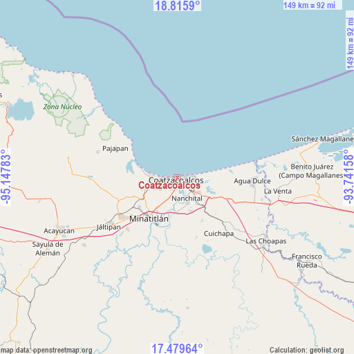
Coatzacoalcos GPS coordinates[2]
18° 8' 56.58" North, 94° 26' 40.92" West
| Map corner | latitude | longitude |
|---|---|---|
| Upper-left | 18.8159°, | -95.14783° |
| Center: | 18.14905°, | -94.4447° |
| Lower-right: | 17.47964°, | -93.74158° |
| Map W x H: | 148.6×148.6 km | = 92.3×92.3mi |
| max Lat: | 32.7° ⇑76.9% North |
| Coatzacoalcos: | 18.14905° |
| min Lat: | ⇓23.1% South 14.53588° |
| min Long | Coatzacoalcos | max Long |
| -117.105° | -94.4447° | -86.73105° |
| W 85.5%⇐ | ⇒14.5% E |
Elevation
Elevation of Coatzacoalcos is 3 m = 10 ft, and this is 1250.7 m = 4103 ft below average elevation for this country.
| Max E: |
3497 m = 11473 ft | 99.8% |
| Avg. | 1253.7 m = 4113 ft | |
| Coatzacoalcos | 3 m = 10 ft | |
Min E: |
-1 m = -3 ft | 0.2% |
See also: Coatzacoalcos elevation on elevation.city.
Geographical zone
Coatzacoalcos is located in North Torrid zone (between Equator and Tropic of Cancer). Distance of this Northern Tropic circle is 587.9 km =365.3 mi to North.| Distance of | km | miles | from Coatzacoalcos |
|---|---|---|---|
| North Pole | 7989.1 | 4964.2 | to North |
| Arctic Circle | 5383.2 | 3345 | to North |
| Tropic Cancer | 587.9 | 365.3 | to North |
| Equator | 2018 | 1253.9 | to South |


Nearby cities:
15 places around Coatzacoalcos: (largest is in red/bold)
• Allende
5.5 km =3.4 mi,  82°
82°
• Calzadas
5.4 km =3.4 mi,  191°
191°
• Centro de Readaptación Social
7.9 km =4.9 mi,  260°
260°
• Colorado
13 km =8.1 mi,  85°
85°
• El Chapo
15.1 km =9.4 mi,  139°
139°
• Fraccionamiento Ciudad Olmeca
11.4 km =7.1 mi,  270°
270°
• Ixhuatlán del Sureste
15.4 km =9.6 mi,  157°
157°
• La Candelaria [Unidad Habitacional]
12.6 km =7.8 mi, 157°
• La Guadalupana
8.2 km =5.1 mi, 258°
• Las Águilas
13.8 km =8.6 mi, 155°
• Lomas de Barrillas
8.6 km =5.3 mi, 269°
• Mundo Nuevo
8.9 km =5.5 mi, 139°
• Nanchital de Lázaro Cárdenas del Río
9.5 km =5.9 mi, 155°
• Puerto Esmeralda
7.7 km =4.8 mi, 268°
• Residencial las Olas
13.3 km =8.3 mi, 255°
In other languages:
- In Spanish: Puerto Mexico, Coatzacoalcos
- In Russian: Коацакоалькос
- In Chinese: 夸察夸爾科斯
Sources, notices
• [Note1] Compared only with cities in Mexico existing in our database
• [Src1] Map data: © OpenStreetMap contributors (CC-BY-SA)
• [Src2] Other city data from geonames.org with taken over terms of usage.
• [Src3] Geographical zone / Annual Mean Temperature by Robert A. Rohde @ Wikipedia
