Puerto Esmeralda geodata
Puerto Esmeralda (Veracruz) is a populated place; located in Mexico in America/Mexico_City (GMT-6) time zone. With population of 3,826 people, there are 2389 cities with bigger population in this country. Compared to other cities in Mexico, 76.9% of cities are located further ↑North; 85.5% of cities are located further ←West and 93.5% of cities have higher elevation than Puerto Esmeralda. Note1


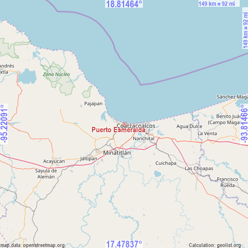
Puerto Esmeralda GPS coordinates[2]
18° 8' 52.008" North, 94° 31' 4.008" West
| Map corner | latitude | longitude |
|---|---|---|
| Upper-left | 18.81464°, | -95.22091° |
| Center: | 18.14778°, | -94.51778° |
| Lower-right: | 17.47837°, | -93.81466° |
| Map W x H: | 148.6×148.6 km | = 92.3×92.3mi |
| max Lat: | 32.7° ⇑76.9% North |
| Puerto Esmeralda: | 18.14778° |
| min Lat: | ⇓23.1% South 14.53588° |
| min Long | Puerto Esmerald | max Long |
| -117.105° | -94.51778° | -86.73105° |
| W 85.5%⇐ | ⇒14.5% E |
Elevation
Elevation of Puerto Esmeralda is 16 m = 52 ft, and this is 1237.7 m = 4061 ft below average elevation for this country.
| Max E: |
3497 m = 11473 ft | 93.5% |
| Avg. | 1253.7 m = 4113 ft | |
| Puerto Esmeralda | 16 m = 52 ft | |
Min E: |
-1 m = -3 ft | 6.5% |
See also: Mexico elevation on elevation.city.
Geographical zone
Puerto Esmeralda is located in North Torrid zone (between Equator and Tropic of Cancer). Distance of this Northern Tropic circle is 588.1 km =365.4 mi to North.| Distance of | km | miles | from Puerto Esmeralda |
|---|---|---|---|
| North Pole | 7989.2 | 4964.3 | to North |
| Arctic Circle | 5383.3 | 3345 | to North |
| Tropic Cancer | 588.1 | 365.4 | to North |
| Equator | 2017.8 | 1253.8 | to South |


Nearby cities:
15 places around Puerto Esmeralda: (largest is in red/bold)
• Allende
13.2 km =8.2 mi,  86°
86°
• Barrancas
11.4 km =7.1 mi,  219°
219°
• Calzadas
8.4 km =5.2 mi,  128°
128°
• Centro de Readaptación Social
1.2 km =0.7 mi,  184°
184°
• Coatzacoalcos
7.7 km =4.8 mi, 88°
• Fraccionamiento Ciudad Olmeca
3.7 km =2.3 mi,  274°
274°
• Jicacal
12.4 km =7.7 mi,  306°
306°
• La Guadalupana
1.5 km =0.9 mi,  191°
191°
• Las Barrillas
9.2 km =5.7 mi,  297°
297°
• Lomas de Barrillas
0.9 km =0.6 mi, 271°
• Los Cerritos
13 km =8.1 mi,  233°
233°
• Mapachapa
14.1 km =8.8 mi,  201°
201°
• Mundo Nuevo
15 km =9.3 mi,  116°
116°
• Nanchital de Lázaro Cárdenas del Río
14.4 km =8.9 mi, 126°
• Residencial las Olas
6 km =3.7 mi,  237°
237°
Sources, notices
• [Note1] Compared only with cities in Mexico existing in our database
• [Src1] Map data: © OpenStreetMap contributors (CC-BY-SA)
• [Src2] Other city data from geonames.org with taken over terms of usage.
• [Src3] Geographical zone / Annual Mean Temperature by Robert A. Rohde @ Wikipedia
