Alpuyeca geodata
Alpuyeca (Morelos) is a populated place; located in Mexico in America/Mexico_City (GMT-6) time zone. With population of 8,330 people, there are 1142 cities with bigger population in this country. Compared to other cities in Mexico, 69.7% of cities are located further ↑North; 53.7% of cities are located further →East and 59.1% of cities have higher elevation than Alpuyeca. Note1


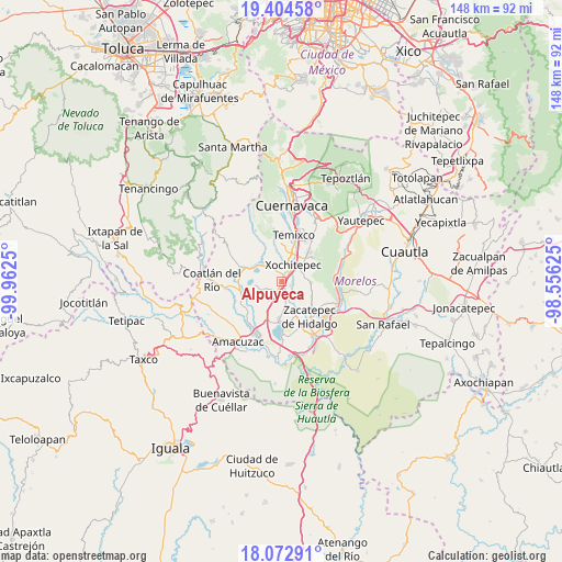
Alpuyeca GPS coordinates[2]
18° 44' 24.216" North, 99° 15' 33.732" West
| Map corner | latitude | longitude |
|---|---|---|
| Upper-left | 19.40458°, | -99.9625° |
| Center: | 18.74006°, | -99.25937° |
| Lower-right: | 18.07291°, | -98.55625° |
| Map W x H: | 148.1×148.1 km | = 92×92mi |
| max Lat: | 32.7° ⇑69.7% North |
| Alpuyeca: | 18.74006° |
| min Lat: | ⇓30.3% South 14.53588° |
| min Long | Alpuyeca | max Long |
| -117.105° | -99.25937° | -86.73105° |
| W 46.3%⇐ | ⇒53.7% E |
Elevation
Elevation of Alpuyeca is 1044 m = 3425 ft, and this is 209.7 m = 688 ft below average elevation for this country.
| Max E: |
3497 m = 11473 ft | 59.1% |
| Avg. | 1253.7 m = 4113 ft | |
| Alpuyeca | 1044 m = 3425 ft | |
Min E: |
-1 m = -3 ft | 40.9% |
See also: Mexico elevation on elevation.city.
Geographical zone
Alpuyeca is located in North Torrid zone (between Equator and Tropic of Cancer). Distance of this Northern Tropic circle is 522.2 km =324.5 mi to North.| Distance of | km | miles | from Alpuyeca |
|---|---|---|---|
| North Pole | 7923.4 | 4923.4 | to North |
| Arctic Circle | 5317.5 | 3304.1 | to North |
| Tropic Cancer | 522.2 | 324.5 | to North |
| Equator | 2083.7 | 1294.8 | to South |


Nearby cities:
15 places around Alpuyeca: (largest is in red/bold)
• Ahuehuetzingo
8.4 km =5.2 mi,  217°
217°
• Atlacholoaya
3.5 km =2.2 mi,  85°
85°
• Benito Juárez (La Monera)
8.2 km =5.1 mi,  353°
353°
• Chiconcuac
7.3 km =4.5 mi,  49°
49°
• Coatetelco
7.1 km =4.4 mi,  260°
260°
• Colonia Ampliación 3 de Mayo
1 km =0.6 mi,  64°
64°
• Colonia la Pintora
2.2 km =1.4 mi,  173°
173°
• El Rodeo
7.9 km =4.9 mi,  302°
302°
• Francisco Villa
5.5 km =3.4 mi,  16°
16°
• La Esperanza
8.2 km =5.1 mi, 21°
• Ninguno [Centro de Readaptación Social de Atlacholoaya]
3.7 km =2.3 mi, 57°
• Unidad Habitacional José María Morelos y Pavón
8.9 km =5.5 mi,  358°
358°
• Xochicalco (Cirenio Longares)
6.7 km =4.2 mi,  321°
321°
• Xochitepec
5.5 km =3.4 mi,  33°
33°
• Xoxocotla
6.4 km =4 mi, 167°
Sources, notices
• [Note1] Compared only with cities in Mexico existing in our database
• [Src1] Map data: © OpenStreetMap contributors (CC-BY-SA)
• [Src2] Other city data from geonames.org with taken over terms of usage.
• [Src3] Geographical zone / Annual Mean Temperature by Robert A. Rohde @ Wikipedia
