Coatepec Harinas geodata
Coatepec Harinas (State of Mexico) is a populated place; located in Mexico in America/Mexico_City (GMT-6) time zone. With population of 7,243 people, there are 1283 cities with bigger population in this country. Compared to other cities in Mexico, 67.1% of cities are located further ↑North; 60.5% of cities are located further →East and 91.1% of cities have lower elevation than Coatepec Harinas. Note1


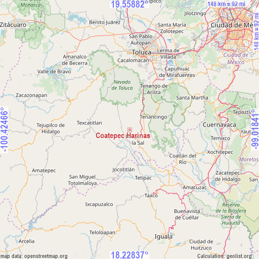
Coatepec Harinas GPS coordinates[2]
18° 53' 41.712" North, 99° 43' 17.508" West
| Map corner | latitude | longitude |
|---|---|---|
| Upper-left | 19.55882°, | -100.42466° |
| Center: | 18.89492°, | -99.72153° |
| Lower-right: | 18.22837°, | -99.01841° |
| Map W x H: | 147.9×147.9 km | = 91.9×91.9mi |
| max Lat: | 32.7° ⇑67.1% North |
| Coatepec Harinas: | 18.89492° |
| min Lat: | ⇓32.9% South 14.53588° |
| min Long | Coatepec Harina | max Long |
| -117.105° | -99.72153° | -86.73105° |
| W 39.5%⇐ | ⇒60.5% E |
Elevation
Elevation of Coatepec Harinas is 2446 m = 8025 ft, and this is 1192.3 m = 3912 ft above average elevation for this country.
| Max E: |
3497 m = 11473 ft | 8.9% |
| Coatepec Harinas | 2446 m 8025 ft | |
| Avg. | 1253.7 m = 4113 ft | |
Min E: |
-1 m = -3 ft | 91.1% |
See also: Mexico elevation on elevation.city.
Geographical zone
Coatepec Harinas is located in North Torrid zone (between Equator and Tropic of Cancer). Distance of this Northern Tropic circle is 505 km =313.8 mi to North.| Distance of | km | miles | from Coatepec Harinas |
|---|---|---|---|
| North Pole | 7906.1 | 4912.6 | to North |
| Arctic Circle | 5300.3 | 3293.5 | to North |
| Tropic Cancer | 505 | 313.8 | to North |
| Equator | 2100.9 | 1305.4 | to South |


Nearby cities:
15 places around Coatepec Harinas: (largest is in red/bold)
• Acuitlapilco
6.8 km =4.2 mi,  283°
283°
• Ahuacatitlán
1.4 km =0.9 mi,  93°
93°
• Cochisquila
3.8 km =2.4 mi,  304°
304°
• El Carmen
2.2 km =1.4 mi,  11°
11°
• Porfirío Díaz
3.8 km =2.4 mi,  351°
351°
• Primera de Analco
5.7 km =3.5 mi, 278°
• Primera de Santa Ana
6.9 km =4.3 mi,  314°
314°
• San Alejo
6.3 km =3.9 mi,  187°
187°
• San Gaspar
6.7 km =4.2 mi,  18°
18°
• San José del Arenal
3.3 km =2.1 mi,  155°
155°
• San Miguel Laderas
2.9 km =1.8 mi,  116°
116°
• Segunda de Analco (La Presa)
6.6 km =4.1 mi, 301°
• Tecomatepec
6.5 km =4 mi, 163°
• Totolmajac
5.2 km =3.2 mi,  46°
46°
• Yerbas Buenas
1.8 km =1.1 mi,  167°
167°
Sources, notices
• [Note1] Compared only with cities in Mexico existing in our database
• [Src1] Map data: © OpenStreetMap contributors (CC-BY-SA)
• [Src2] Other city data from geonames.org with taken over terms of usage.
• [Src3] Geographical zone / Annual Mean Temperature by Robert A. Rohde @ Wikipedia
