Acuitlapilco geodata
Acuitlapilco (State of Mexico) is a populated place; located in Mexico in America/Mexico_City (GMT-6) time zone. With population of 1,723 people, there are 5036 cities with bigger population in this country. Compared to other cities in Mexico, 66.8% of cities are located further ↑North; 61.3% of cities are located further →East and 81.3% of cities have lower elevation than Acuitlapilco. Note1


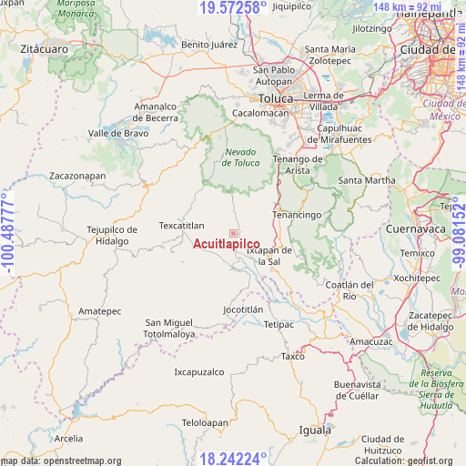
Acuitlapilco GPS coordinates[2]
18° 54' 31.428" North, 99° 47' 4.704" West
| Map corner | latitude | longitude |
|---|---|---|
| Upper-left | 19.57258°, | -100.48777° |
| Center: | 18.90873°, | -99.78464° |
| Lower-right: | 18.24224°, | -99.08152° |
| Map W x H: | 147.9×147.9 km | = 91.9×91.9mi |
| max Lat: | 32.7° ⇑66.8% North |
| Acuitlapilco: | 18.90873° |
| min Lat: | ⇓33.2% South 14.53588° |
| min Long | Acuitlapilco | max Long |
| -117.105° | -99.78464° | -86.73105° |
| W 38.7%⇐ | ⇒61.3% E |
Elevation
Elevation of Acuitlapilco is 2172 m = 7126 ft, and this is 918.3 m = 3013 ft above average elevation for this country.
| Max E: |
3497 m = 11473 ft | 18.7% |
| Acuitlapilco | 2172 m 7126 ft | |
| Avg. | 1253.7 m = 4113 ft | |
Min E: |
-1 m = -3 ft | 81.3% |
See also: Mexico elevation on elevation.city.
Geographical zone
Acuitlapilco is located in North Torrid zone (between Equator and Tropic of Cancer). Distance of this Northern Tropic circle is 503.5 km =312.9 mi to North.| Distance of | km | miles | from Acuitlapilco |
|---|---|---|---|
| North Pole | 7904.6 | 4911.7 | to North |
| Arctic Circle | 5298.7 | 3292.5 | to North |
| Tropic Cancer | 503.5 | 312.9 | to North |
| Equator | 2102.5 | 1306.4 | to South |


Nearby cities:
15 places around Acuitlapilco: (largest is in red/bold)
• Chiltepec de Hidalgo
5.3 km =3.3 mi,  274°
274°
• Coatepec Harinas
6.8 km =4.2 mi,  103°
103°
• Cochisquila
3.6 km =2.2 mi,  80°
80°
• Cruz de Piedra
4.7 km =2.9 mi,  318°
318°
• Ixtlahuaca de Villada
2.7 km =1.7 mi,  296°
296°
• Loma de Acuitlapilco
3.4 km =2.1 mi,  357°
357°
• Porfirío Díaz
6.5 km =4 mi,  69°
69°
• Primera de Analco
1.2 km =0.7 mi,  125°
125°
• Primera de Santa Ana
3.7 km =2.3 mi,  27°
27°
• San Antonio Pachuquilla
6.3 km =3.9 mi,  244°
244°
• San Fernando
7 km =4.3 mi,  22°
22°
• San José del Progreso
3 km =1.9 mi,  344°
344°
• Segunda de Analco (La Presa)
2.1 km =1.3 mi, 26°
• Segunda de Zacanguillo
4.6 km =2.9 mi,  10°
10°
• Zacatones (San Felipe de Jesús)
6.3 km =3.9 mi, 359°
Sources, notices
• [Note1] Compared only with cities in Mexico existing in our database
• [Src1] Map data: © OpenStreetMap contributors (CC-BY-SA)
• [Src2] Other city data from geonames.org with taken over terms of usage.
• [Src3] Geographical zone / Annual Mean Temperature by Robert A. Rohde @ Wikipedia
