Ahuacatitlán geodata
Ahuacatitlán (State of Mexico) is a populated place; located in Mexico in America/Mexico_City (GMT-6) time zone. With population of 1,387 people, there are 6236 cities with bigger population in this country. Compared to other cities in Mexico, 67.1% of cities are located further ↑North; 60.3% of cities are located further →East and 86.6% of cities have lower elevation than Ahuacatitlán. Note1


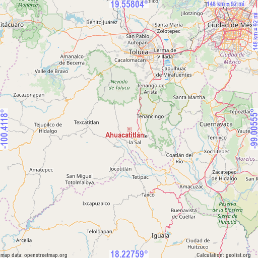
Ahuacatitlán GPS coordinates[2]
18° 53' 38.904" North, 99° 42' 31.212" West
| Map corner | latitude | longitude |
|---|---|---|
| Upper-left | 19.55804°, | -100.4118° |
| Center: | 18.89414°, | -99.70867° |
| Lower-right: | 18.22759°, | -99.00555° |
| Map W x H: | 147.9×147.9 km | = 91.9×91.9mi |
| max Lat: | 32.7° ⇑67.1% North |
| Ahuacatitlán: | 18.89414° |
| min Lat: | ⇓32.9% South 14.53588° |
| min Long | Ahuacatitlán | max Long |
| -117.105° | -99.70867° | -86.73105° |
| W 39.7%⇐ | ⇒60.3% E |
Elevation
Elevation of Ahuacatitlán is 2299 m = 7543 ft, and this is 1045.3 m = 3429 ft above average elevation for this country.
| Max E: |
3497 m = 11473 ft | 13.4% |
| Ahuacatitlán | 2299 m 7543 ft | |
| Avg. | 1253.7 m = 4113 ft | |
Min E: |
-1 m = -3 ft | 86.6% |
See also: Mexico elevation on elevation.city.
Geographical zone
Ahuacatitlán is located in North Torrid zone (between Equator and Tropic of Cancer). Distance of this Northern Tropic circle is 505.1 km =313.9 mi to North.| Distance of | km | miles | from Ahuacatitlán |
|---|---|---|---|
| North Pole | 7906.2 | 4912.7 | to North |
| Arctic Circle | 5300.3 | 3293.5 | to North |
| Tropic Cancer | 505.1 | 313.9 | to North |
| Equator | 2100.8 | 1305.4 | to South |


Nearby cities:
15 places around Ahuacatitlán: (largest is in red/bold)
• Coatepec Harinas
1.4 km =0.9 mi,  273°
273°
• Cochisquila
5 km =3.1 mi,  296°
296°
• El Carmen
2.4 km =1.5 mi,  337°
337°
• El Refugio
7.1 km =4.4 mi,  185°
185°
• Ixtapan de la Sal
6.5 km =4 mi,  149°
149°
• Porfirío Díaz
4.3 km =2.7 mi,  333°
333°
• Primera de Analco
7.1 km =4.4 mi,  277°
277°
• San Alejo
6.5 km =4 mi,  199°
199°
• San Gaspar
6.5 km =4 mi,  6°
6°
• San José del Arenal
3 km =1.9 mi,  179°
179°
• San Miguel Laderas
1.7 km =1.1 mi,  134°
134°
• Tecomatepec
6.2 km =3.9 mi, 175°
• Totolmajac
4.4 km =2.7 mi,  33°
33°
• Yerbas Buenas
1.9 km =1.2 mi,  209°
209°
• Zacango
7 km =4.3 mi, 9°
Sources, notices
• [Note1] Compared only with cities in Mexico existing in our database
• [Src1] Map data: © OpenStreetMap contributors (CC-BY-SA)
• [Src2] Other city data from geonames.org with taken over terms of usage.
• [Src3] Geographical zone / Annual Mean Temperature by Robert A. Rohde @ Wikipedia
