Porfirío Díaz geodata
Porfirío Díaz (State of Mexico) is a populated place; located in Mexico in America/Mexico_City (GMT-6) time zone. With population of 1,409 people, there are 6137 cities with bigger population in this country. Compared to other cities in Mexico, 66.3% of cities are located further ↑North; 60.5% of cities are located further →East and 91.2% of cities have lower elevation than Porfirío Díaz. Note1


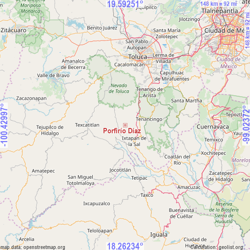
Porfirío Díaz GPS coordinates[2]
18° 55' 43.5" North, 99° 43' 36.624" West
| Map corner | latitude | longitude |
|---|---|---|
| Upper-left | 19.59251°, | -100.42997° |
| Center: | 18.92875°, | -99.72684° |
| Lower-right: | 18.26234°, | -99.02372° |
| Map W x H: | 147.9×147.9 km | = 91.9×91.9mi |
| max Lat: | 32.7° ⇑66.3% North |
| Porfirío Díaz: | 18.92875° |
| min Lat: | ⇓33.7% South 14.53588° |
| min Long | Porfirío Díaz | max Long |
| -117.105° | -99.72684° | -86.73105° |
| W 39.5%⇐ | ⇒60.5% E |
Elevation
Elevation of Porfirío Díaz is 2449 m = 8035 ft, and this is 1195.3 m = 3922 ft above average elevation for this country.
| Max E: |
3497 m = 11473 ft | 8.8% |
| Porfirío Díaz | 2449 m 8035 ft | |
| Avg. | 1253.7 m = 4113 ft | |
Min E: |
-1 m = -3 ft | 91.2% |
See also: Mexico elevation on elevation.city.
Geographical zone
Porfirío Díaz is located in North Torrid zone (between Equator and Tropic of Cancer). Distance of this Northern Tropic circle is 501.2 km =311.4 mi to North.| Distance of | km | miles | from Porfirío Díaz |
|---|---|---|---|
| North Pole | 7902.4 | 4910.3 | to North |
| Arctic Circle | 5296.5 | 3291.1 | to North |
| Tropic Cancer | 501.2 | 311.4 | to North |
| Equator | 2104.7 | 1307.8 | to South |


Nearby cities:
15 places around Porfirío Díaz: (largest is in red/bold)
• Agua Amarga
4.7 km =2.9 mi,  325°
325°
• Ahuacatitlán
4.3 km =2.7 mi,  153°
153°
• Coatepec Harinas
3.8 km =2.4 mi,  171°
171°
• Cochisquila
3 km =1.9 mi,  237°
237°
• El Carmen
1.9 km =1.2 mi, 149°
• Primera de Analco
5.9 km =3.7 mi, 240°
• Primera de Santa Ana
4.5 km =2.8 mi,  283°
283°
• San Fernando
5.4 km =3.4 mi,  320°
320°
• San Gaspar
3.7 km =2.3 mi,  45°
45°
• San Mateo Coapexco
5.8 km =3.6 mi, 51°
• Segunda de Analco (La Presa)
5.1 km =3.2 mi,  266°
266°
• Segunda de Zacanguillo
5.7 km =3.5 mi,  293°
293°
• Totolmajac
4.3 km =2.7 mi,  92°
92°
• Yerbas Buenas
5.6 km =3.5 mi, 170°
• Zacango
4.3 km =2.7 mi,  44°
44°
Sources, notices
• [Note1] Compared only with cities in Mexico existing in our database
• [Src1] Map data: © OpenStreetMap contributors (CC-BY-SA)
• [Src2] Other city data from geonames.org with taken over terms of usage.
• [Src3] Geographical zone / Annual Mean Temperature by Robert A. Rohde @ Wikipedia
