Coacotla geodata
Coacotla (Veracruz) is a populated place; located in Mexico in America/Mexico_City (GMT-6) time zone. With population of 6,873 people, there are 1356 cities with bigger population in this country. Compared to other cities in Mexico, 79.3% of cities are located further ↑North; 85.2% of cities are located further ←West and 87.7% of cities have higher elevation than Coacotla. Note1


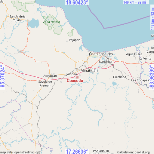
Coacotla GPS coordinates[2]
17° 56' 11.616" North, 94° 40' 1.596" West
| Map corner | latitude | longitude |
|---|---|---|
| Upper-left | 18.60423°, | -95.37024° |
| Center: | 17.93656°, | -94.66711° |
| Lower-right: | 17.26636°, | -93.96399° |
| Map W x H: | 148.8×148.8 km | = 92.5×92.5mi |
| max Lat: | 32.7° ⇑79.3% North |
| Coacotla: | 17.93656° |
| min Lat: | ⇓20.7% South 14.53588° |
| min Long | Coacotla | max Long |
| -117.105° | -94.66711° | -86.73105° |
| W 85.2%⇐ | ⇒14.8% E |
Elevation
Elevation of Coacotla is 31 m = 102 ft, and this is 1222.7 m = 4011 ft below average elevation for this country.
| Max E: |
3497 m = 11473 ft | 87.7% |
| Avg. | 1253.7 m = 4113 ft | |
| Coacotla | 31 m = 102 ft | |
Min E: |
-1 m = -3 ft | 12.3% |
See also: Mexico elevation on elevation.city.
Geographical zone
Coacotla is located in North Torrid zone (between Equator and Tropic of Cancer). Distance of this Northern Tropic circle is 611.6 km =380 mi to North.| Distance of | km | miles | from Coacotla |
|---|---|---|---|
| North Pole | 8012.7 | 4978.9 | to North |
| Arctic Circle | 5406.8 | 3359.6 | to North |
| Tropic Cancer | 611.6 | 380 | to North |
| Equator | 1994.4 | 1239.3 | to South |


Nearby cities:
15 places around Coacotla: (largest is in red/bold)
• Chinameca
9.6 km =6 mi,  352°
352°
• Colonia Luis Donaldo Colosio
8.7 km =5.4 mi,  43°
43°
• Cosoleacaque
7.7 km =4.8 mi,  25°
25°
• El Naranjito
9.3 km =5.8 mi, 43°
• Fraccionamiento los Prados
5.5 km =3.4 mi, 32°
• Hermenegildo J. Aldana
9.7 km =6 mi, 36°
• Jáltipan de Morelos
5.9 km =3.7 mi,  302°
302°
• La Victoria
8.7 km =5.4 mi,  160°
160°
• Las Jacarandas
9.5 km =5.9 mi, 39°
• Las Lomas de Tacamichapan
9 km =5.6 mi,  209°
209°
• Limonta
7 km =4.3 mi,  131°
131°
• Monte Alto
6.1 km =3.8 mi, 134°
• Oteapan
7.2 km =4.5 mi,  0°
0°
• San Pedro Mártir
7.6 km =4.7 mi,  52°
52°
• Zaragoza
3.5 km =2.2 mi, 47°
Sources, notices
• [Note1] Compared only with cities in Mexico existing in our database
• [Src1] Map data: © OpenStreetMap contributors (CC-BY-SA)
• [Src2] Other city data from geonames.org with taken over terms of usage.
• [Src3] Geographical zone / Annual Mean Temperature by Robert A. Rohde @ Wikipedia
