La Victoria geodata
La Victoria (Veracruz) is a populated place; located in Mexico in America/Mexico_City (GMT-6) time zone. With population of 610 people, there are 14138 cities with bigger population in this country. Compared to other cities in Mexico, 80% of cities are located further ↑North; 85.2% of cities are located further ←West and 98.1% of cities have higher elevation than La Victoria. Note1


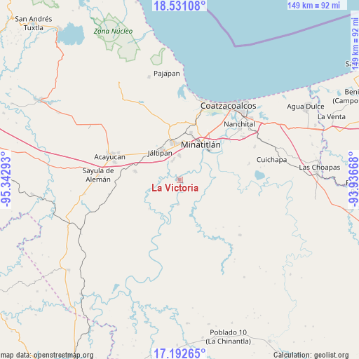
La Victoria GPS coordinates[2]
17° 51' 47.232" North, 94° 38' 23.28" West
| Map corner | latitude | longitude |
|---|---|---|
| Upper-left | 18.53108°, | -95.34293° |
| Center: | 17.86312°, | -94.6398° |
| Lower-right: | 17.19265°, | -93.93668° |
| Map W x H: | 148.8×148.8 km | = 92.5×92.5mi |
| max Lat: | 32.7° ⇑80% North |
| La Victoria: | 17.86312° |
| min Lat: | ⇓20% South 14.53588° |
| min Long | La Victoria | max Long |
| -117.105° | -94.6398° | -86.73105° |
| W 85.2%⇐ | ⇒14.8% E |
Elevation
Elevation of La Victoria is 8 m = 26 ft, and this is 1245.7 m = 4087 ft below average elevation for this country.
| Max E: |
3497 m = 11473 ft | 98.1% |
| Avg. | 1253.7 m = 4113 ft | |
| La Victoria | 8 m = 26 ft | |
Min E: |
-1 m = -3 ft | 1.9% |
See also: Mexico elevation on elevation.city.
Geographical zone
La Victoria is located in North Torrid zone (between Equator and Tropic of Cancer). Distance of this Northern Tropic circle is 619.7 km =385.1 mi to North.| Distance of | km | miles | from La Victoria |
|---|---|---|---|
| North Pole | 8020.9 | 4984 | to North |
| Arctic Circle | 5415 | 3364.7 | to North |
| Tropic Cancer | 619.7 | 385.1 | to North |
| Equator | 1986.2 | 1234.2 | to South |


Nearby cities:
15 places around La Victoria: (largest is in red/bold)
• Coacotla
8.7 km =5.4 mi,  340°
340°
• Colonia Luis Donaldo Colosio
14.8 km =9.2 mi,  11°
11°
• El Jagüey
13.9 km =8.6 mi,  34°
34°
• Emilio Carranza (Salinas)
10.9 km =6.8 mi,  126°
126°
• Fraccionamiento los Prados
12.7 km =7.9 mi,  0°
0°
• Hidalgotitlán
10.3 km =6.4 mi,  184°
184°
• Jáltipan de Morelos
13.8 km =8.6 mi,  325°
325°
• Las Lomas
12.9 km =8 mi,  40°
40°
• Las Lomas de Tacamichapan
7.3 km =4.5 mi,  272°
272°
• Las Ánimas
9.6 km =6 mi,  52°
52°
• Limonta
4.2 km =2.6 mi, 33°
• Monte Alto
4.1 km =2.5 mi,  19°
19°
• San Cristóbal
12.1 km =7.5 mi,  119°
119°
• San Pedro Mártir
13.2 km =8.2 mi, 13°
• Zaragoza
10.5 km =6.5 mi,  358°
358°
Sources, notices
• [Note1] Compared only with cities in Mexico existing in our database
• [Src1] Map data: © OpenStreetMap contributors (CC-BY-SA)
• [Src2] Other city data from geonames.org with taken over terms of usage.
• [Src3] Geographical zone / Annual Mean Temperature by Robert A. Rohde @ Wikipedia
