Chivela geodata
Chivela (Oaxaca) is a populated place; located in Mexico in America/Mexico_City (GMT-6) time zone. With population of 624 people, there are 13853 cities with bigger population in this country. Compared to other cities in Mexico, 92.7% of cities are located further ↑North; 84.6% of cities are located further ←West and 75% of cities have higher elevation than Chivela. Note1


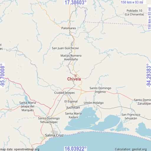
Chivela GPS coordinates[2]
16° 42' 49.716" North, 94° 59' 49.02" West
| Map corner | latitude | longitude |
|---|---|---|
| Upper-left | 17.38603°, | -95.70008° |
| Center: | 16.71381°, | -94.99695° |
| Lower-right: | 16.03922°, | -94.29383° |
| Map W x H: | 149.8×149.8 km | = 93.1×93.1mi |
| max Lat: | 32.7° ⇑92.7% North |
| Chivela: | 16.71381° |
| min Lat: | ⇓7.3% South 14.53588° |
| min Long | Chivela | max Long |
| -117.105° | -94.99695° | -86.73105° |
| W 84.6%⇐ | ⇒15.4% E |
Elevation
Elevation of Chivela is 223 m = 732 ft, and this is 1030.7 m = 3382 ft below average elevation for this country.
| Max E: |
3497 m = 11473 ft | 75% |
| Avg. | 1253.7 m = 4113 ft | |
| Chivela | 223 m = 732 ft | |
Min E: |
-1 m = -3 ft | 25% |
See also: Mexico elevation on elevation.city.
Geographical zone
Chivela is located in North Torrid zone (between Equator and Tropic of Cancer). Distance of this Northern Tropic circle is 747.5 km =464.5 mi to North.| Distance of | km | miles | from Chivela |
|---|---|---|---|
| North Pole | 8148.7 | 5063.4 | to North |
| Arctic Circle | 5542.8 | 3444.1 | to North |
| Tropic Cancer | 747.5 | 464.5 | to North |
| Equator | 1858.4 | 1154.8 | to South |


Nearby cities:
15 places around Chivela: (largest is in red/bold)
• Buenavista
13.9 km =8.6 mi,  329°
329°
• Chivixhuyo
11.4 km =7.1 mi,  17°
17°
• Colonia Progreso
13.1 km =8.1 mi,  317°
317°
• El Barrio de la Soledad
15.8 km =9.8 mi,  309°
309°
• Fraccionamiento Loma Azul
13.9 km =8.6 mi, 310°
• Guigubá
13.7 km =8.5 mi, 313°
• Hidalgo Norte
19.4 km =12.1 mi,  342°
342°
• La Ventosa
18.8 km =11.7 mi,  163°
163°
• Llano Suchiapa
18 km =11.2 mi, 340°
• Lázaro Cárdenas
14.7 km =9.1 mi,  83°
83°
• Matías Romero
18.9 km =11.7 mi,  346°
346°
• Niza Conejo
13 km =8.1 mi, 325°
• Santa María Petapa
17.6 km =10.9 mi, 312°
• Santiago Ixtaltepec
10.1 km =6.3 mi,  106°
106°
• Santo Domingo Petapa
19.2 km =11.9 mi, 307°
Sources, notices
• [Note1] Compared only with cities in Mexico existing in our database
• [Src1] Map data: © OpenStreetMap contributors (CC-BY-SA)
• [Src2] Other city data from geonames.org with taken over terms of usage.
• [Src3] Geographical zone / Annual Mean Temperature by Robert A. Rohde @ Wikipedia
