Chivixhuyo geodata
Chivixhuyo (Oaxaca) is a populated place; located in Mexico in America/Mexico_City (GMT-6) time zone. With population of 773 people, there are 11306 cities with bigger population in this country. Compared to other cities in Mexico, 91.6% of cities are located further ↑North; 84.7% of cities are located further ←West and 74.1% of cities have higher elevation than Chivixhuyo. Note1


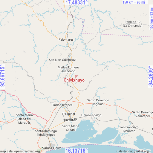
Chivixhuyo GPS coordinates[2]
16° 48' 41.184" North, 94° 57' 50.472" West
| Map corner | latitude | longitude |
|---|---|---|
| Upper-left | 17.48331°, | -95.66715° |
| Center: | 16.81144°, | -94.96402° |
| Lower-right: | 16.13718°, | -94.2609° |
| Map W x H: | 149.7×149.7 km | = 93×93mi |
| max Lat: | 32.7° ⇑91.6% North |
| Chivixhuyo: | 16.81144° |
| min Lat: | ⇓8.4% South 14.53588° |
| min Long | Chivixhuyo | max Long |
| -117.105° | -94.96402° | -86.73105° |
| W 84.7%⇐ | ⇒15.3% E |
Elevation
Elevation of Chivixhuyo is 250 m = 820 ft, and this is 1003.7 m = 3293 ft below average elevation for this country.
| Max E: |
3497 m = 11473 ft | 74.1% |
| Avg. | 1253.7 m = 4113 ft | |
| Chivixhuyo | 250 m = 820 ft | |
Min E: |
-1 m = -3 ft | 25.9% |
See also: Mexico elevation on elevation.city.
Geographical zone
Chivixhuyo is located in North Torrid zone (between Equator and Tropic of Cancer). Distance of this Northern Tropic circle is 736.7 km =457.8 mi to North.| Distance of | km | miles | from Chivixhuyo |
|---|---|---|---|
| North Pole | 8137.8 | 5056.6 | to North |
| Arctic Circle | 5531.9 | 3437.4 | to North |
| Tropic Cancer | 736.7 | 457.8 | to North |
| Equator | 1869.3 | 1161.5 | to South |


Nearby cities:
15 places around Chivixhuyo: (largest is in red/bold)
• Barreña
14 km =8.7 mi,  0°
0°
• Buenavista
10.6 km =6.6 mi,  275°
275°
• Chivela
11.4 km =7.1 mi,  197°
197°
• Colonia Progreso
12.4 km =7.7 mi,  264°
264°
• Colonia Rincón Viejo
12.2 km =7.6 mi,  313°
313°
• El Bajío
11.5 km =7.1 mi,  318°
318°
• El Barrio de la Soledad
15.8 km =9.8 mi,  266°
266°
• Fraccionamiento Loma Azul
14.2 km =8.8 mi, 262°
• Guigubá
13.5 km =8.4 mi, 263°
• Hidalgo Norte
12.1 km =7.5 mi, 308°
• Llano Suchiapa
11.3 km =7 mi,  302°
302°
• Lázaro Cárdenas
14.4 km =8.9 mi,  129°
129°
• Matías Romero
11 km =6.8 mi, 313°
• Niza Conejo
10.9 km =6.8 mi, 268°
• Santiago Ixtaltepec
15 km =9.3 mi,  155°
155°
Sources, notices
• [Note1] Compared only with cities in Mexico existing in our database
• [Src1] Map data: © OpenStreetMap contributors (CC-BY-SA)
• [Src2] Other city data from geonames.org with taken over terms of usage.
• [Src3] Geographical zone / Annual Mean Temperature by Robert A. Rohde @ Wikipedia
