Chigtón geodata
Chigtón (Chiapas) is a populated place; located in Mexico in America/Mexico_City (GMT-6) time zone. With population of 960 people, there are 9064 cities with bigger population in this country. Compared to other cities in Mexico, 91.1% of cities are located further ↑North; 89.4% of cities are located further ←West and 58.2% of cities have higher elevation than Chigtón. Note1


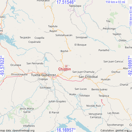
Chigtón GPS coordinates[2]
16° 50' 37.356" North, 92° 52' 23.124" West
| Map corner | latitude | longitude |
|---|---|---|
| Upper-left | 17.51546°, | -93.57622° |
| Center: | 16.84371°, | -92.87309° |
| Lower-right: | 16.16957°, | -92.16997° |
| Map W x H: | 149.6×149.7 km | = 93×93mi |
| max Lat: | 32.7° ⇑91.1% North |
| Chigtón: | 16.84371° |
| min Lat: | ⇓8.9% South 14.53588° |
| min Long | Chigtón | max Long |
| -117.105° | -92.87309° | -86.73105° |
| W 89.4%⇐ | ⇒10.6% E |
Elevation
Elevation of Chigtón is 1098 m = 3602 ft, and this is 155.7 m = 511 ft below average elevation for this country.
| Max E: |
3497 m = 11473 ft | 58.2% |
| Avg. | 1253.7 m = 4113 ft | |
| Chigtón | 1098 m = 3602 ft | |
Min E: |
-1 m = -3 ft | 41.8% |
See also: Mexico elevation on elevation.city.
Geographical zone
Chigtón is located in North Torrid zone (between Equator and Tropic of Cancer). Distance of this Northern Tropic circle is 733.1 km =455.5 mi to North.| Distance of | km | miles | from Chigtón |
|---|---|---|---|
| North Pole | 8134.2 | 5054.4 | to North |
| Arctic Circle | 5528.3 | 3435.1 | to North |
| Tropic Cancer | 733.1 | 455.5 | to North |
| Equator | 1872.8 | 1163.7 | to South |


Nearby cities:
15 places around Chigtón: (largest is in red/bold)
• Cacaté
4.1 km =2.5 mi,  87°
87°
• El Nopal
8.1 km =5 mi,  21°
21°
• El Zapotillo
8.4 km =5.2 mi,  264°
264°
• Francisco Javier Mina
2.8 km =1.7 mi,  162°
162°
• Ixtapa
5.7 km =3.5 mi,  217°
217°
• Las Cañitas
7.6 km =4.7 mi,  211°
211°
• Modelo (El Zapotal)
5.8 km =3.6 mi,  265°
265°
• Nachauc
8.2 km =5.1 mi,  80°
80°
• Nuevo San Miguel Mitontic (Punta de Piedad)
9.2 km =5.7 mi,  238°
238°
• Pugchén Chico
6.7 km =4.2 mi, 94°
• Pugchén Mumuntic
5.7 km =3.5 mi,  66°
66°
• Soyaló
7.6 km =4.7 mi,  314°
314°
• Victórico R. Grajales (Iglesia Vieja)
6.3 km =3.9 mi,  347°
347°
• Yalchitom
7.2 km =4.5 mi,  116°
116°
• Yaltem
8.8 km =5.5 mi, 89°
Sources, notices
• [Note1] Compared only with cities in Mexico existing in our database
• [Src1] Map data: © OpenStreetMap contributors (CC-BY-SA)
• [Src2] Other city data from geonames.org with taken over terms of usage.
• [Src3] Geographical zone / Annual Mean Temperature by Robert A. Rohde @ Wikipedia
