Nachauc geodata
Nachauc (Chiapas) is a populated place; located in Mexico in America/Mexico_City (GMT-6) time zone. With population of 694 people, there are 12543 cities with bigger population in this country. Compared to other cities in Mexico, 91% of cities are located further ↑North; 89.9% of cities are located further ←West and 83.3% of cities have lower elevation than Nachauc. Note1


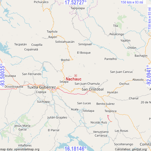
Nachauc GPS coordinates[2]
16° 51' 20.016" North, 92° 47' 49.992" West
| Map corner | latitude | longitude |
|---|---|---|
| Upper-left | 17.52727°, | -93.50035° |
| Center: | 16.85556°, | -92.79722° |
| Lower-right: | 16.18146°, | -92.0941° |
| Map W x H: | 149.6×149.6 km | = 93×93mi |
| max Lat: | 32.7° ⇑91% North |
| Nachauc: | 16.85556° |
| min Lat: | ⇓9% South 14.53588° |
| min Long | Nachauc | max Long |
| -117.105° | -92.79722° | -86.73105° |
| W 89.9%⇐ | ⇒10.1% E |
Elevation
Elevation of Nachauc is 2226 m = 7303 ft, and this is 972.3 m = 3190 ft above average elevation for this country.
| Max E: |
3497 m = 11473 ft | 16.7% |
| Nachauc | 2226 m 7303 ft | |
| Avg. | 1253.7 m = 4113 ft | |
Min E: |
-1 m = -3 ft | 83.3% |
See also: Mexico elevation on elevation.city.
Geographical zone
Nachauc is located in North Torrid zone (between Equator and Tropic of Cancer). Distance of this Northern Tropic circle is 731.8 km =454.7 mi to North.| Distance of | km | miles | from Nachauc |
|---|---|---|---|
| North Pole | 8132.9 | 5053.5 | to North |
| Arctic Circle | 5527 | 3434.3 | to North |
| Tropic Cancer | 731.8 | 454.7 | to North |
| Equator | 1874.2 | 1164.6 | to South |


Nearby cities:
15 places around Nachauc: (largest is in red/bold)
• Cacaté
4.2 km =2.6 mi,  254°
254°
• Chigtón
8.2 km =5.1 mi,  260°
260°
• El Nopal
8 km =5 mi,  320°
320°
• Francisco Javier Mina
8.3 km =5.2 mi,  240°
240°
• Jolnachoj
7 km =4.3 mi,  18°
18°
• Jomalho
8.7 km =5.4 mi,  101°
101°
• Muctahuitz
4.6 km =2.9 mi,  71°
71°
• Noctic
7.2 km =4.5 mi,  152°
152°
• Pugchén Chico
2.3 km =1.4 mi,  217°
217°
• Pugchén Mumuntic
3 km =1.9 mi,  288°
288°
• San Cristobalito
6.8 km =4.2 mi,  339°
339°
• Santa Ana
8.4 km =5.2 mi,  129°
129°
• Yaaltz'Unun
6 km =3.7 mi, 154°
• Yalchitom
4.8 km =3 mi,  199°
199°
• Yaltem
1.5 km =0.9 mi, 151°
Sources, notices
• [Note1] Compared only with cities in Mexico existing in our database
• [Src1] Map data: © OpenStreetMap contributors (CC-BY-SA)
• [Src2] Other city data from geonames.org with taken over terms of usage.
• [Src3] Geographical zone / Annual Mean Temperature by Robert A. Rohde @ Wikipedia
