Soyaló geodata
Soyaló (Chiapas) is a seat of a second-order administrative division; located in Mexico in America/Mexico_City (GMT-6) time zone. With population of 4,014 people, there are 2270 cities with bigger population in this country. Compared to other cities in Mexico, 90.4% of cities are located further ↑North; 89.1% of cities are located further ←West and 55.7% of cities have higher elevation than Soyaló. Note1


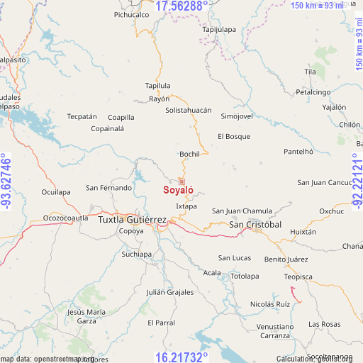
Soyaló GPS coordinates[2]
16° 53' 28.68" North, 92° 55' 27.588" West
| Map corner | latitude | longitude |
|---|---|---|
| Upper-left | 17.56288°, | -93.62746° |
| Center: | 16.8913°, | -92.92433° |
| Lower-right: | 16.21732°, | -92.22121° |
| Map W x H: | 149.6×149.6 km | = 93×93mi |
| max Lat: | 32.7° ⇑90.4% North |
| Soyaló: | 16.8913° |
| min Lat: | ⇓9.6% South 14.53588° |
| min Long | Soyaló | max Long |
| -117.105° | -92.92433° | -86.73105° |
| W 89.1%⇐ | ⇒10.9% E |
Elevation
Elevation of Soyaló is 1172 m = 3845 ft, and this is 81.7 m = 268 ft below average elevation for this country.
| Max E: |
3497 m = 11473 ft | 55.7% |
| Avg. | 1253.7 m = 4113 ft | |
| Soyaló | 1172 m = 3845 ft | |
Min E: |
-1 m = -3 ft | 44.3% |
See also: Mexico elevation on elevation.city.
Geographical zone
Soyaló is located in North Torrid zone (between Equator and Tropic of Cancer). Distance of this Northern Tropic circle is 727.8 km =452.2 mi to North.| Distance of | km | miles | from Soyaló |
|---|---|---|---|
| North Pole | 8128.9 | 5051.1 | to North |
| Arctic Circle | 5523 | 3431.8 | to North |
| Tropic Cancer | 727.8 | 452.2 | to North |
| Equator | 1878.1 | 1167 | to South |


Nearby cities:
15 places around Soyaló: (largest is in red/bold)
• Buenavista
9.5 km =5.9 mi,  61°
61°
• Chigtón
7.6 km =4.7 mi,  134°
134°
• El Copal
8.5 km =5.3 mi,  358°
358°
• El Horizonte
3.9 km =2.4 mi,  252°
252°
• El Nopal
8.8 km =5.5 mi,  75°
75°
• El Zapotillo
6.7 km =4.2 mi,  205°
205°
• Ixtapa
10 km =6.2 mi,  168°
168°
• Miguel Hidalgo
7.3 km =4.5 mi,  221°
221°
• Modelo (El Zapotal)
5.8 km =3.6 mi,  183°
183°
• Monte Grande
8.4 km =5.2 mi,  51°
51°
• San Vicente
7.1 km =4.4 mi,  0°
0°
• Venustiano Carranza
7.8 km =4.8 mi, 355°
• Venustiano Carranza
8.6 km =5.3 mi,  273°
273°
• Victórico R. Grajales (Iglesia Vieja)
4.2 km =2.6 mi, 78°
• Yerbabuena Isbontick
7.8 km =4.8 mi, 53°
Sources, notices
• [Note1] Compared only with cities in Mexico existing in our database
• [Src1] Map data: © OpenStreetMap contributors (CC-BY-SA)
• [Src2] Other city data from geonames.org with taken over terms of usage.
• [Src3] Geographical zone / Annual Mean Temperature by Robert A. Rohde @ Wikipedia
