Chapopote Núñez geodata
Chapopote Núñez (Veracruz) is a populated place; located in Mexico in America/Mexico_City (GMT-6) time zone. With population of 2,675 people, there are 3307 cities with bigger population in this country. Compared to other cities in Mexico, 75.4% of cities are located further ↓South; 67.5% of cities are located further ←West and 88% of cities have higher elevation than Chapopote Núñez. Note1


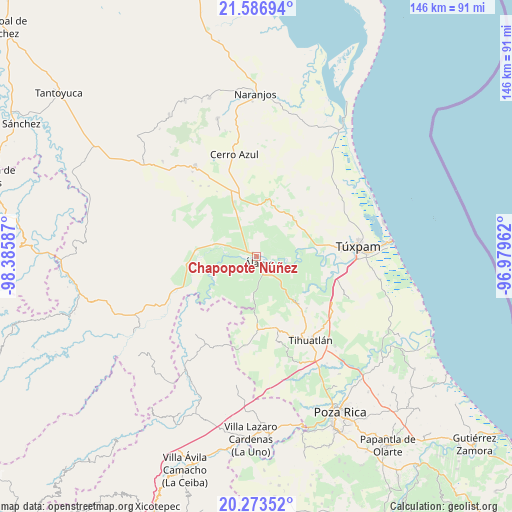
Chapopote Núñez GPS coordinates[2]
20° 55' 54.012" North, 97° 40' 57.864" West
| Map corner | latitude | longitude |
|---|---|---|
| Upper-left | 21.58694°, | -98.38587° |
| Center: | 20.93167°, | -97.68274° |
| Lower-right: | 20.27352°, | -96.97962° |
| Map W x H: | 146×146 km | = 90.7×90.7mi |
| max Lat: | 32.7° ⇑24.6% North |
| Chapopote Núñez: | 20.93167° |
| min Lat: | ⇓75.4% South 14.53588° |
| min Long | Chapopote Núñ | max Long |
| -117.105° | -97.68274° | -86.73105° |
| W 67.5%⇐ | ⇒32.5% E |
Elevation
Elevation of Chapopote Núñez is 30 m = 98 ft, and this is 1223.7 m = 4015 ft below average elevation for this country.
| Max E: |
3497 m = 11473 ft | 88% |
| Avg. | 1253.7 m = 4113 ft | |
| Chapopote Núñez | 30 m = 98 ft | |
Min E: |
-1 m = -3 ft | 12% |
See also: Mexico elevation on elevation.city.
Geographical zone
Chapopote Núñez is located in North Torrid zone (between Equator and Tropic of Cancer). Distance of this Northern Tropic circle is 278.5 km =173.1 mi to North.| Distance of | km | miles | from Chapopote Núñez |
|---|---|---|---|
| North Pole | 7679.7 | 4771.9 | to North |
| Arctic Circle | 5073.8 | 3152.7 | to North |
| Tropic Cancer | 278.5 | 173.1 | to North |
| Equator | 2327.4 | 1446.2 | to South |


Nearby cities:
15 places around Chapopote Núñez: (largest is in red/bold)
• Agua Nacida
3.2 km =2 mi,  231°
231°
• Estación Chapapote (Puerta Siete)
4.6 km =2.9 mi,  292°
292°
• Estero del Ídolo
5.3 km =3.3 mi,  152°
152°
• General A. Tejeda y su A. Graciano Sánchez
3.8 km =2.4 mi,  319°
319°
• Hidalgo Amajac
6.3 km =3.9 mi,  118°
118°
• Jardín Viejo
3.9 km =2.4 mi,  125°
125°
• La Concepción
7.6 km =4.7 mi,  177°
177°
• La Tortuga
2.4 km =1.5 mi,  204°
204°
• La Unión
4.7 km =2.9 mi,  157°
157°
• Loma Bonita
0.9 km =0.6 mi,  35°
35°
• Ojital Ciruelo
6.1 km =3.8 mi, 290°
• Puerta Siete
2.4 km =1.5 mi,  303°
303°
• Rodríguez Clara
7 km =4.3 mi, 225°
• Vara Alta
7.2 km =4.5 mi,  6°
6°
• Álamo
2.4 km =1.5 mi, 161°
Sources, notices
• [Note1] Compared only with cities in Mexico existing in our database
• [Src1] Map data: © OpenStreetMap contributors (CC-BY-SA)
• [Src2] Other city data from geonames.org with taken over terms of usage.
• [Src3] Geographical zone / Annual Mean Temperature by Robert A. Rohde @ Wikipedia
