Hidalgo Amajac geodata
Hidalgo Amajac (Veracruz) is a populated place; located in Mexico in America/Mexico_City (GMT-6) time zone. With population of 1,241 people, there are 6992 cities with bigger population in this country. Compared to other cities in Mexico, 74.9% of cities are located further ↓South; 68.1% of cities are located further ←West and 92.5% of cities have higher elevation than Hidalgo Amajac. Note1


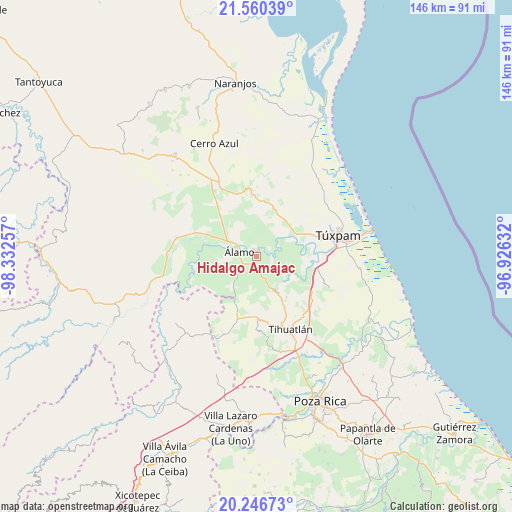
Hidalgo Amajac GPS coordinates[2]
20° 54' 18" North, 97° 37' 45.984" West
| Map corner | latitude | longitude |
|---|---|---|
| Upper-left | 21.56039°, | -98.33257° |
| Center: | 20.905°, | -97.62944° |
| Lower-right: | 20.24673°, | -96.92632° |
| Map W x H: | 146.1×146.1 km | = 90.8×90.8mi |
| max Lat: | 32.7° ⇑25.1% North |
| Hidalgo Amajac: | 20.905° |
| min Lat: | ⇓74.9% South 14.53588° |
| min Long | Hidalgo Amajac | max Long |
| -117.105° | -97.62944° | -86.73105° |
| W 68.1%⇐ | ⇒31.9% E |
Elevation
Elevation of Hidalgo Amajac is 18 m = 59 ft, and this is 1235.7 m = 4054 ft below average elevation for this country.
| Max E: |
3497 m = 11473 ft | 92.5% |
| Avg. | 1253.7 m = 4113 ft | |
| Hidalgo Amajac | 18 m = 59 ft | |
Min E: |
-1 m = -3 ft | 7.5% |
See also: Mexico elevation on elevation.city.
Geographical zone
Hidalgo Amajac is located in North Torrid zone (between Equator and Tropic of Cancer). Distance of this Northern Tropic circle is 281.5 km =174.9 mi to North.| Distance of | km | miles | from Hidalgo Amajac |
|---|---|---|---|
| North Pole | 7682.6 | 4773.7 | to North |
| Arctic Circle | 5076.8 | 3154.6 | to North |
| Tropic Cancer | 281.5 | 174.9 | to North |
| Equator | 2324.4 | 1444.3 | to South |


Nearby cities:
15 places around Hidalgo Amajac: (largest is in red/bold)
• Cerro Dulce
6.9 km =4.3 mi,  165°
165°
• Chapopote Núñez
6.3 km =3.9 mi,  298°
298°
• Citlaltépetl
5.1 km =3.2 mi,  153°
153°
• Estero del Ídolo
3.5 km =2.2 mi,  240°
240°
• Jardín Viejo
2.5 km =1.6 mi,  287°
287°
• Kilómetro Treinta y Tres (Paso Real)
3.7 km =2.3 mi,  93°
93°
• La Concepción
7 km =4.3 mi,  228°
228°
• La Reforma
5.2 km =3.2 mi,  212°
212°
• La Tortuga
6.6 km =4.1 mi,  276°
276°
• La Unión
4 km =2.5 mi,  249°
249°
• Loma Bonita
6.2 km =3.9 mi,  306°
306°
• Raudal Nuevo
5.6 km =3.5 mi,  118°
118°
• Tumbadero
6.7 km =4.2 mi,  52°
52°
• Villa Hermosa
7.4 km =4.6 mi,  37°
37°
• Álamo
4.8 km =3 mi, 278°
Sources, notices
• [Note1] Compared only with cities in Mexico existing in our database
• [Src1] Map data: © OpenStreetMap contributors (CC-BY-SA)
• [Src2] Other city data from geonames.org with taken over terms of usage.
• [Src3] Geographical zone / Annual Mean Temperature by Robert A. Rohde @ Wikipedia
