Puente Campuzano geodata
Puente Campuzano (Guerrero) is a populated place; located in Mexico in America/Mexico_City (GMT-6) time zone. With population of 659 people, there are 13168 cities with bigger population in this country. Compared to other cities in Mexico, 73.1% of cities are located further ↑North; 58.3% of cities are located further →East and 54.7% of cities have higher elevation than Puente Campuzano. Note1


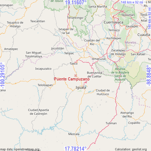
Puente Campuzano GPS coordinates[2]
18° 27' 1.44" North, 99° 35' 16.512" West
| Map corner | latitude | longitude |
|---|---|---|
| Upper-left | 19.11607°, | -100.29105° |
| Center: | 18.4504°, | -99.58792° |
| Lower-right: | 17.78214°, | -98.8848° |
| Map W x H: | 148.3×148.3 km | = 92.1×92.1mi |
| max Lat: | 32.7° ⇑73.1% North |
| Puente Campuzano: | 18.4504° |
| min Lat: | ⇓26.9% South 14.53588° |
| min Long | Puente Campuzan | max Long |
| -117.105° | -99.58792° | -86.73105° |
| W 41.7%⇐ | ⇒58.3% E |
Elevation
Elevation of Puente Campuzano is 1209 m = 3967 ft, and this is 44.7 m = 147 ft below average elevation for this country.
| Max E: |
3497 m = 11473 ft | 54.7% |
| Avg. | 1253.7 m = 4113 ft | |
| Puente Campuzano | 1209 m = 3967 ft | |
Min E: |
-1 m = -3 ft | 45.3% |
See also: Mexico elevation on elevation.city.
Geographical zone
Puente Campuzano is located in North Torrid zone (between Equator and Tropic of Cancer). Distance of this Northern Tropic circle is 554.4 km =344.5 mi to North.| Distance of | km | miles | from Puente Campuzano |
|---|---|---|---|
| North Pole | 7955.6 | 4943.4 | to North |
| Arctic Circle | 5349.7 | 3324.1 | to North |
| Tropic Cancer | 554.4 | 344.5 | to North |
| Equator | 2051.5 | 1274.7 | to South |


Nearby cities:
15 places around Puente Campuzano: (largest is in red/bold)
• Atzala
10.5 km =6.5 mi,  313°
313°
• Colonia 15 de Septiembre
10.5 km =6.5 mi,  139°
139°
• Colonia Francisco Villa
10.3 km =6.4 mi, 138°
• Dolores
7.8 km =4.8 mi,  337°
337°
• El Ejido (Ejido Guerrero)
6.1 km =3.8 mi, 344°
• El Naranjo
8 km =5 mi, 135°
• Huixtac
7.6 km =4.7 mi,  279°
279°
• Juliantla
10.5 km =6.5 mi,  19°
19°
• Mexcaltepec
5.7 km =3.5 mi,  127°
127°
• Paintla
9.2 km =5.7 mi, 309°
• Santiago Temixco
6.8 km =4.2 mi,  304°
304°
• Taxco el Viejo
3.7 km =2.3 mi,  6°
6°
• Tecalpulco
4.5 km =2.8 mi, 339°
• Temaxcalapa
9.4 km =5.8 mi,  252°
252°
• Tlamacazapa
10.6 km =6.6 mi,  60°
60°
Sources, notices
• [Note1] Compared only with cities in Mexico existing in our database
• [Src1] Map data: © OpenStreetMap contributors (CC-BY-SA)
• [Src2] Other city data from geonames.org with taken over terms of usage.
• [Src3] Geographical zone / Annual Mean Temperature by Robert A. Rohde @ Wikipedia
