Cadereyta geodata
Cadereyta (Nuevo León) is a populated place; located in Mexico in America/Monterrey (GMT-6) time zone. With population of 67,994 people, there are 177 cities with bigger population in this country. Compared to other cities in Mexico, 93% of cities are located further ↓South; 63.8% of cities are located further →East and 72.2% of cities have higher elevation than Cadereyta. Note1


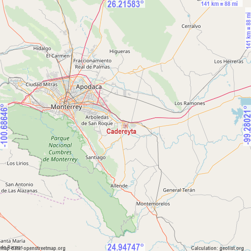
Cadereyta GPS coordinates[2]
25° 34' 59.988" North, 99° 58' 59.988" West
| Map corner | latitude | longitude |
|---|---|---|
| Upper-left | 26.21583°, | -100.68646° |
| Center: | 25.58333°, | -99.98333° |
| Lower-right: | 24.94747°, | -99.28021° |
| Map W x H: | 141×141 km | = 87.6×87.6mi |
| max Lat: | 32.7° ⇑7% North |
| Cadereyta: | 25.58333° |
| min Lat: | ⇓93% South 14.53588° |
| min Long | Cadereyta | max Long |
| -117.105° | -99.98333° | -86.73105° |
| W 36.2%⇐ | ⇒63.8% E |
Elevation
Elevation of Cadereyta is 321 m = 1053 ft, and this is 932.7 m = 3060 ft below average elevation for this country.
| Max E: |
3497 m = 11473 ft | 72.2% |
| Avg. | 1253.7 m = 4113 ft | |
| Cadereyta | 321 m = 1053 ft | |
Min E: |
-1 m = -3 ft | 27.8% |
See also: Cadereyta elevation on elevation.city.
Geographical zone
Cadereyta is located in North temperate zone (between Tropic of Cancer and the Arctic Circle). Distance of this Northern Tropic circle is 238.7 km =148.3 mi to South.| Distance of | km | miles | from Cadereyta |
|---|---|---|---|
| North Pole | 7162.5 | 4450.6 | to North |
| Arctic Circle | 4556.6 | 2831.3 | to North |
| Tropic Cancer | 238.7 | 148.3 | to South |
| Equator | 2844.6 | 1767.6 | to South |


Nearby cities:
15 places around Cadereyta: (largest is in red/bold)
• Bosques de San Pedro
19.8 km =12.3 mi,  275°
275°
• Cadereyta Jiménez
1.9 km =1.2 mi,  288°
288°
• Centro Habitacional Burócratas de Guadalupe
18 km =11.2 mi, 289°
• Ciudad Benito Juárez
13.3 km =8.3 mi,  302°
302°
• Dieciséis de Septiembre
16.7 km =10.4 mi,  272°
272°
• Dulces Nombres
19 km =11.8 mi,  328°
328°
• Héctor Caballero
15.5 km =9.6 mi, 292°
• Jardines de la Silla (Jardines)
21.1 km =13.1 mi, 284°
• Loma la Paz
20.8 km =12.9 mi,  313°
313°
• Monte Kristal
18 km =11.2 mi, 285°
• Palmitos
13.4 km =8.3 mi,  174°
174°
• San Antonio
9.7 km =6 mi, 309°
• San Juan
15 km =9.3 mi,  107°
107°
• Valle de Juárez
18.6 km =11.6 mi, 289°
• Valle de Vaquerías
17.3 km =10.7 mi, 288°
Sources, notices
• [Note1] Compared only with cities in Mexico existing in our database
• [Src1] Map data: © OpenStreetMap contributors (CC-BY-SA)
• [Src2] Other city data from geonames.org with taken over terms of usage.
• [Src3] Geographical zone / Annual Mean Temperature by Robert A. Rohde @ Wikipedia
