Palmitos geodata
Palmitos (Nuevo León) is a populated place; located in Mexico in America/Monterrey (GMT-6) time zone. With population of 670 people, there are 12949 cities with bigger population in this country. Compared to other cities in Mexico, 92.6% of cities are located further ↓South; 63.6% of cities are located further →East and 72% of cities have higher elevation than Palmitos. Note1


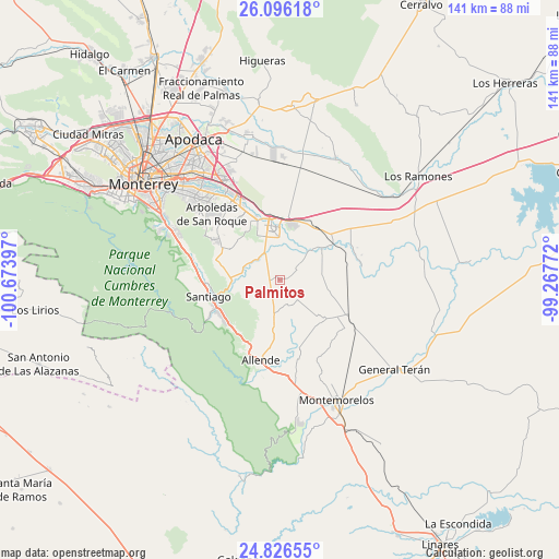
Palmitos GPS coordinates[2]
25° 27' 46.944" North, 99° 58' 15.024" West
| Map corner | latitude | longitude |
|---|---|---|
| Upper-left | 26.09618°, | -100.67397° |
| Center: | 25.46304°, | -99.97084° |
| Lower-right: | 24.82655°, | -99.26772° |
| Map W x H: | 141.2×141.2 km | = 87.7×87.7mi |
| max Lat: | 32.7° ⇑7.4% North |
| Palmitos: | 25.46304° |
| min Lat: | ⇓92.6% South 14.53588° |
| min Long | Palmitos | max Long |
| -117.105° | -99.97084° | -86.73105° |
| W 36.4%⇐ | ⇒63.6% E |
Elevation
Elevation of Palmitos is 330 m = 1083 ft, and this is 923.7 m = 3031 ft below average elevation for this country.
| Max E: |
3497 m = 11473 ft | 72% |
| Avg. | 1253.7 m = 4113 ft | |
| Palmitos | 330 m = 1083 ft | |
Min E: |
-1 m = -3 ft | 28% |
See also: Mexico elevation on elevation.city.
Geographical zone
Palmitos is located in North temperate zone (between Tropic of Cancer and the Arctic Circle). Distance of this Northern Tropic circle is 225.3 km =140 mi to South.| Distance of | km | miles | from Palmitos |
|---|---|---|---|
| North Pole | 7175.8 | 4458.8 | to North |
| Arctic Circle | 4569.9 | 2839.6 | to North |
| Tropic Cancer | 225.3 | 140 | to South |
| Equator | 2831.2 | 1759.2 | to South |


Nearby cities:
15 places around Palmitos: (largest is in red/bold)
• Atongo de Abajo
11.7 km =7.3 mi,  187°
187°
• Cadereyta
13.4 km =8.3 mi,  354°
354°
• Cadereyta Jiménez
14.3 km =8.9 mi, 347°
• Ciudad Benito Juárez
24 km =14.9 mi,  328°
328°
• Ciudad de Allende
21.2 km =13.2 mi, 191°
• Dieciséis de Septiembre
22.9 km =14.2 mi,  308°
308°
• El Fraile
12.3 km =7.6 mi,  162°
162°
• Héctor Caballero
24.7 km =15.3 mi,  320°
320°
• Paso Hondo
20.2 km =12.6 mi,  179°
179°
• Pueblo Nuevo
21.3 km =13.2 mi,  83°
83°
• San Antonio
21.4 km =13.3 mi,  335°
335°
• San Juan
15.8 km =9.8 mi,  55°
55°
• Santa Isabel y Dolores
21.1 km =13.1 mi,  67°
67°
• Santiago
18.7 km =11.6 mi,  257°
257°
• Valle de Vaquerías
25.8 km =16 mi, 316°
Sources, notices
• [Note1] Compared only with cities in Mexico existing in our database
• [Src1] Map data: © OpenStreetMap contributors (CC-BY-SA)
• [Src2] Other city data from geonames.org with taken over terms of usage.
• [Src3] Geographical zone / Annual Mean Temperature by Robert A. Rohde @ Wikipedia
