Barretal geodata
Barretal (Tamaulipas) is a populated place; located in Mexico in America/Monterrey (GMT-6) time zone. With population of 3,400 people, there are 2676 cities with bigger population in this country. Compared to other cities in Mexico, 90.2% of cities are located further ↓South; 51.5% of cities are located further →East and 75.6% of cities have higher elevation than Barretal. Note1


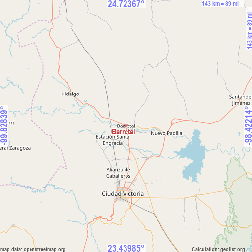
Barretal GPS coordinates[2]
24° 5' 0.132" North, 99° 7' 30.936" West
| Map corner | latitude | longitude |
|---|---|---|
| Upper-left | 24.72367°, | -99.82839° |
| Center: | 24.08337°, | -99.12526° |
| Lower-right: | 23.43985°, | -98.42214° |
| Map W x H: | 142.7×142.7 km | = 88.7×88.7mi |
| max Lat: | 32.7° ⇑9.8% North |
| Barretal: | 24.08337° |
| min Lat: | ⇓90.2% South 14.53588° |
| min Long | Barretal | max Long |
| -117.105° | -99.12526° | -86.73105° |
| W 48.5%⇐ | ⇒51.5% E |
Elevation
Elevation of Barretal is 201 m = 659 ft, and this is 1052.7 m = 3454 ft below average elevation for this country.
| Max E: |
3497 m = 11473 ft | 75.6% |
| Avg. | 1253.7 m = 4113 ft | |
| Barretal | 201 m = 659 ft | |
Min E: |
-1 m = -3 ft | 24.4% |
See also: Mexico elevation on elevation.city.
Geographical zone
Barretal is located in North temperate zone (between Tropic of Cancer and the Arctic Circle). Distance of this Northern Tropic circle is 71.9 km =44.7 mi to South.| Distance of | km | miles | from Barretal |
|---|---|---|---|
| North Pole | 7329.2 | 4554.2 | to North |
| Arctic Circle | 4723.4 | 2935 | to North |
| Tropic Cancer | 71.9 | 44.7 | to South |
| Equator | 2677.8 | 1663.9 | to South |


Nearby cities:
15 places around Barretal: (largest is in red/bold)
• Aquiles Serdán
29.4 km =18.3 mi,  181°
181°
• Balconcitos (Balcones)
11.3 km =7 mi,  223°
223°
• Congregación Caballeros
25 km =15.5 mi,  190°
190°
• Cruz y Cruz
6.6 km =4.1 mi,  284°
284°
• Estación Santa Engracia
10.9 km =6.8 mi,  225°
225°
• Guadalupe Victoria
2.1 km =1.3 mi,  242°
242°
• Guemes
22 km =13.7 mi,  146°
146°
• Guillermo Zúñiga
10.8 km =6.7 mi, 225°
• Juan Rincón
18.8 km =11.7 mi,  203°
203°
• La Soledad
4.7 km =2.9 mi,  93°
93°
• Nueva Villa de Padilla
23.1 km =14.4 mi,  99°
99°
• Oyama
14.7 km =9.1 mi,  289°
289°
• Plan de Ayala
3.5 km =2.2 mi,  170°
170°
• San Cayetano
19.8 km =12.3 mi, 171°
• San José de la Flores
20.1 km =12.5 mi, 177°
Sources, notices
• [Note1] Compared only with cities in Mexico existing in our database
• [Src1] Map data: © OpenStreetMap contributors (CC-BY-SA)
• [Src2] Other city data from geonames.org with taken over terms of usage.
• [Src3] Geographical zone / Annual Mean Temperature by Robert A. Rohde @ Wikipedia
