Ayahualulco geodata
Ayahualulco (Guerrero) is a populated place; located in Mexico in America/Mexico_City (GMT-6) time zone. With population of 3,994 people, there are 2284 cities with bigger population in this country. Compared to other cities in Mexico, 83.1% of cities are located further ↑North; 52.4% of cities are located further →East and 50.1% of cities have higher elevation than Ayahualulco. Note1


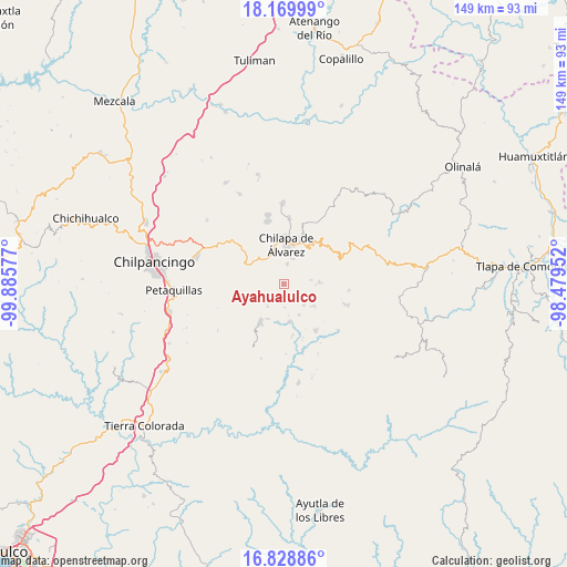
Ayahualulco GPS coordinates[2]
17° 30' 2.376" North, 99° 10' 57.504" West
| Map corner | latitude | longitude |
|---|---|---|
| Upper-left | 18.16999°, | -99.88577° |
| Center: | 17.50066°, | -99.18264° |
| Lower-right: | 16.82886°, | -98.47952° |
| Map W x H: | 149.1×149.1 km | = 92.6×92.6mi |
| max Lat: | 32.7° ⇑83.1% North |
| Ayahualulco: | 17.50066° |
| min Lat: | ⇓16.9% South 14.53588° |
| min Long | Ayahualulco | max Long |
| -117.105° | -99.18264° | -86.73105° |
| W 47.6%⇐ | ⇒52.4% E |
Elevation
Elevation of Ayahualulco is 1425 m = 4675 ft, and this is 171.3 m = 562 ft above average elevation for this country.
| Max E: |
3497 m = 11473 ft | 50.1% |
| Ayahualulco | 1425 m 4675 ft | |
| Avg. | 1253.7 m = 4113 ft | |
Min E: |
-1 m = -3 ft | 49.9% |
See also: Mexico elevation on elevation.city.
Geographical zone
Ayahualulco is located in North Torrid zone (between Equator and Tropic of Cancer). Distance of this Northern Tropic circle is 660 km =410.1 mi to North.| Distance of | km | miles | from Ayahualulco |
|---|---|---|---|
| North Pole | 8061.2 | 5009 | to North |
| Arctic Circle | 5455.3 | 3389.8 | to North |
| Tropic Cancer | 660 | 410.1 | to North |
| Equator | 1945.9 | 1209.1 | to South |


Nearby cities:
15 places around Ayahualulco: (largest is in red/bold)
• Acalco
1.8 km =1.1 mi,  71°
71°
• Atenxoxola
4.4 km =2.7 mi,  108°
108°
• Axopilco
3.6 km =2.2 mi,  324°
324°
• El Jagüey
4.1 km =2.5 mi, 106°
• Los Amates
5.2 km =3.2 mi,  348°
348°
• San Ángel
2.8 km =1.7 mi,  139°
139°
• Tlamixtlahuacan
4.6 km =2.9 mi,  273°
273°
• Tlanipatla
5.3 km =3.3 mi,  46°
46°
• Tlaxinga (Clatzinga)
2.5 km =1.6 mi,  333°
333°
• Xiloxuchicán
4 km =2.5 mi, 139°
• Xochitempa
3.3 km =2.1 mi,  24°
24°
• Zinantla
3.4 km =2.1 mi, 350°
• Zinzintitlán
5.2 km =3.2 mi,  37°
37°
• Zizicazapa
3.6 km =2.2 mi,  62°
62°
• Zoquitipa
4.1 km =2.5 mi,  358°
358°
Sources, notices
• [Note1] Compared only with cities in Mexico existing in our database
• [Src1] Map data: © OpenStreetMap contributors (CC-BY-SA)
• [Src2] Other city data from geonames.org with taken over terms of usage.
• [Src3] Geographical zone / Annual Mean Temperature by Robert A. Rohde @ Wikipedia
