Atenxoxola geodata
Atenxoxola (Guerrero) is a populated place; located in Mexico in America/Mexico_City (GMT-6) time zone. With population of 1,770 people, there are 4908 cities with bigger population in this country. Compared to other cities in Mexico, 83.2% of cities are located further ↑North; 51.7% of cities are located further →East and 50.1% of cities have higher elevation than Atenxoxola. Note1


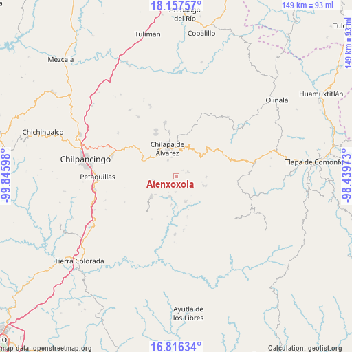
Atenxoxola GPS coordinates[2]
17° 29' 17.484" North, 99° 8' 34.26" West
| Map corner | latitude | longitude |
|---|---|---|
| Upper-left | 18.15757°, | -99.84598° |
| Center: | 17.48819°, | -99.14285° |
| Lower-right: | 16.81634°, | -98.43973° |
| Map W x H: | 149.1×149.1 km | = 92.6×92.6mi |
| max Lat: | 32.7° ⇑83.2% North |
| Atenxoxola: | 17.48819° |
| min Lat: | ⇓16.8% South 14.53588° |
| min Long | Atenxoxola | max Long |
| -117.105° | -99.14285° | -86.73105° |
| W 48.3%⇐ | ⇒51.7% E |
Elevation
Elevation of Atenxoxola is 1424 m = 4672 ft, and this is 170.3 m = 559 ft above average elevation for this country.
| Max E: |
3497 m = 11473 ft | 50.1% |
| Atenxoxola | 1424 m 4672 ft | |
| Avg. | 1253.7 m = 4113 ft | |
Min E: |
-1 m = -3 ft | 49.9% |
See also: Mexico elevation on elevation.city.
Geographical zone
Atenxoxola is located in North Torrid zone (between Equator and Tropic of Cancer). Distance of this Northern Tropic circle is 661.4 km =411 mi to North.| Distance of | km | miles | from Atenxoxola |
|---|---|---|---|
| North Pole | 8062.6 | 5009.9 | to North |
| Arctic Circle | 5456.7 | 3390.6 | to North |
| Tropic Cancer | 661.4 | 411 | to North |
| Equator | 1944.5 | 1208.3 | to South |


Nearby cities:
15 places around Atenxoxola: (largest is in red/bold)
• Acalco
3.2 km =2 mi,  307°
307°
• Alcozacán
5.4 km =3.4 mi,  70°
70°
• Atzacoaloya
6.5 km =4 mi,  4°
4°
• Ayahualulco
4.4 km =2.7 mi,  288°
288°
• El Jagüey
0.4 km =0.2 mi,  303°
303°
• Juxtlahuaca
6.6 km =4.1 mi,  183°
183°
• San Ángel
2.5 km =1.6 mi,  253°
253°
• Tlalixtlahuacán
2.5 km =1.6 mi,  96°
96°
• Tlanipatla
5.1 km =3.2 mi,  356°
356°
• Tlaxinga (Clatzinga)
6.5 km =4 mi, 304°
• Xiloxuchicán
2.3 km =1.4 mi,  224°
224°
• Xochitempa
5.2 km =3.2 mi,  327°
327°
• Zelocotitlán
6.1 km =3.8 mi,  140°
140°
• Zinzintitlán
5.6 km =3.5 mi,  349°
349°
• Zizicazapa
3.2 km =2 mi,  341°
341°
Sources, notices
• [Note1] Compared only with cities in Mexico existing in our database
• [Src1] Map data: © OpenStreetMap contributors (CC-BY-SA)
• [Src2] Other city data from geonames.org with taken over terms of usage.
• [Src3] Geographical zone / Annual Mean Temperature by Robert A. Rohde @ Wikipedia
