Tlamixtlahuacan geodata
Tlamixtlahuacan (Guerrero) is a populated place; located in Mexico in America/Mexico_City (GMT-6) time zone. With population of 3,031 people, there are 2968 cities with bigger population in this country. Compared to other cities in Mexico, 83.1% of cities are located further ↑North; 53.2% of cities are located further →East and 54.5% of cities have higher elevation than Tlamixtlahuacan. Note1


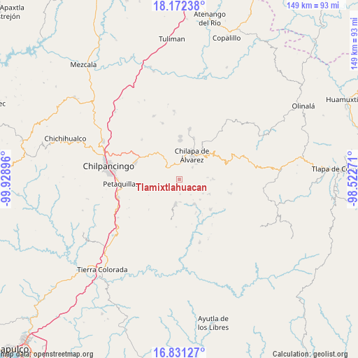
Tlamixtlahuacan GPS coordinates[2]
17° 30' 11.016" North, 99° 13' 32.988" West
| Map corner | latitude | longitude |
|---|---|---|
| Upper-left | 18.17238°, | -99.92896° |
| Center: | 17.50306°, | -99.22583° |
| Lower-right: | 16.83127°, | -98.52271° |
| Map W x H: | 149.1×149.1 km | = 92.6×92.6mi |
| max Lat: | 32.7° ⇑83.1% North |
| Tlamixtlahuacan: | 17.50306° |
| min Lat: | ⇓16.9% South 14.53588° |
| min Long | Tlamixtlahuacan | max Long |
| -117.105° | -99.22583° | -86.73105° |
| W 46.8%⇐ | ⇒53.2% E |
Elevation
Elevation of Tlamixtlahuacan is 1218 m = 3996 ft, and this is 35.7 m = 117 ft below average elevation for this country.
| Max E: |
3497 m = 11473 ft | 54.5% |
| Avg. | 1253.7 m = 4113 ft | |
| Tlamixtlahuacan | 1218 m = 3996 ft | |
Min E: |
-1 m = -3 ft | 45.5% |
See also: Mexico elevation on elevation.city.
Geographical zone
Tlamixtlahuacan is located in North Torrid zone (between Equator and Tropic of Cancer). Distance of this Northern Tropic circle is 659.8 km =410 mi to North.| Distance of | km | miles | from Tlamixtlahuacan |
|---|---|---|---|
| North Pole | 8060.9 | 5008.8 | to North |
| Arctic Circle | 5455 | 3389.6 | to North |
| Tropic Cancer | 659.8 | 410 | to North |
| Equator | 1946.2 | 1209.3 | to South |


Nearby cities:
15 places around Tlamixtlahuacan: (largest is in red/bold)
• Achigca
3.3 km =2.1 mi,  197°
197°
• Acuentla
3 km =1.9 mi,  305°
305°
• Ahuexotitlán
3.4 km =2.1 mi,  325°
325°
• Axopilco
3.6 km =2.2 mi,  43°
43°
• Ayahualulco
4.6 km =2.9 mi,  93°
93°
• Cuauhtenango
5.2 km =3.2 mi,  22°
22°
• Cuonetzingo
5 km =3.1 mi,  302°
302°
• Los Amates
5.9 km =3.7 mi, 36°
• Ostocapa
6.2 km =3.9 mi,  177°
177°
• Popoyatlajco
4.6 km =2.9 mi,  266°
266°
• Tlacoaxtla
6.3 km =3.9 mi, 24°
• Tlaxinga (Clatzinga)
4 km =2.5 mi,  59°
59°
• Tonalapa
2.2 km =1.4 mi,  230°
230°
• Zinantla
5.1 km =3.2 mi,  52°
52°
• Zoquitipa
5.9 km =3.7 mi, 49°
Sources, notices
• [Note1] Compared only with cities in Mexico existing in our database
• [Src1] Map data: © OpenStreetMap contributors (CC-BY-SA)
• [Src2] Other city data from geonames.org with taken over terms of usage.
• [Src3] Geographical zone / Annual Mean Temperature by Robert A. Rohde @ Wikipedia
