Soledad Atzompa geodata
Soledad Atzompa (Veracruz) is a populated place; located in Mexico in America/Mexico_City (GMT-6) time zone. With population of 3,964 people, there are 2299 cities with bigger population in this country. Compared to other cities in Mexico, 70% of cities are located further ↑North; 72.6% of cities are located further ←West and 87.6% of cities have lower elevation than Soledad Atzompa. Note1


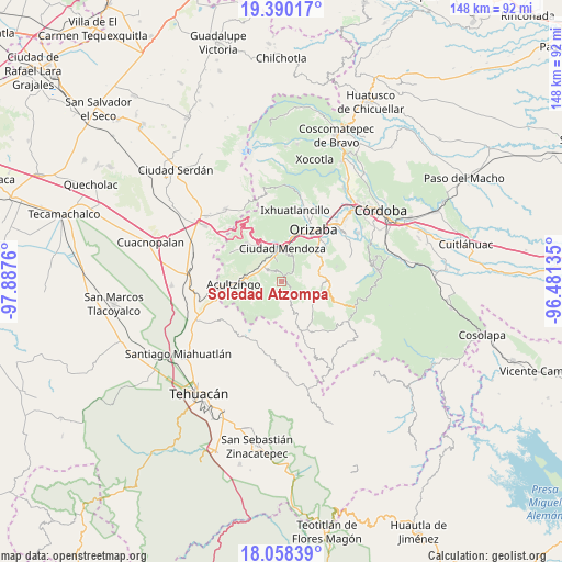
Soledad Atzompa GPS coordinates[2]
18° 43' 32.124" North, 97° 11' 4.092" West
| Map corner | latitude | longitude |
|---|---|---|
| Upper-left | 19.39017°, | -97.8876° |
| Center: | 18.72559°, | -97.18447° |
| Lower-right: | 18.05839°, | -96.48135° |
| Map W x H: | 148.1×148.1 km | = 92×92mi |
| max Lat: | 32.7° ⇑70% North |
| Soledad Atzompa: | 18.72559° |
| min Lat: | ⇓30% South 14.53588° |
| min Long | Soledad Atzompa | max Long |
| -117.105° | -97.18447° | -86.73105° |
| W 72.6%⇐ | ⇒27.4% E |
Elevation
Elevation of Soledad Atzompa is 2329 m = 7641 ft, and this is 1075.3 m = 3528 ft above average elevation for this country.
| Max E: |
3497 m = 11473 ft | 12.4% |
| Soledad Atzompa | 2329 m 7641 ft | |
| Avg. | 1253.7 m = 4113 ft | |
Min E: |
-1 m = -3 ft | 87.6% |
See also: Mexico elevation on elevation.city.
Geographical zone
Soledad Atzompa is located in North Torrid zone (between Equator and Tropic of Cancer). Distance of this Northern Tropic circle is 523.8 km =325.5 mi to North.| Distance of | km | miles | from Soledad Atzompa |
|---|---|---|---|
| North Pole | 7925 | 4924.4 | to North |
| Arctic Circle | 5319.1 | 3305.1 | to North |
| Tropic Cancer | 523.8 | 325.5 | to North |
| Equator | 2082.1 | 1293.8 | to South |


Nearby cities:
15 places around Soledad Atzompa: (largest is in red/bold)
• Acatla
4.4 km =2.7 mi,  306°
306°
• Acultzinapa
4.4 km =2.7 mi,  184°
184°
• Atexcalco
1.3 km =0.8 mi,  173°
173°
• El Campanario
5.2 km =3.2 mi,  349°
349°
• Huitzila
1.7 km =1.1 mi,  116°
116°
• Huixtitla
3 km =1.9 mi,  340°
340°
• Mexcala
3.9 km =2.4 mi,  148°
148°
• Monterrey
4.3 km =2.7 mi,  67°
67°
• Soledad Atzompa
4.9 km =3 mi,  47°
47°
• Tetlatzinga
3.4 km =2.1 mi, 179°
• Tlalpan
3.2 km =2 mi, 51°
• Tlatilpa
4.3 km =2.7 mi,  77°
77°
• Tlatzala
4.6 km =2.9 mi,  85°
85°
• Xiquila
2 km =1.2 mi,  209°
209°
• Xonotla
4 km =2.5 mi,  60°
60°
Sources, notices
• [Note1] Compared only with cities in Mexico existing in our database
• [Src1] Map data: © OpenStreetMap contributors (CC-BY-SA)
• [Src2] Other city data from geonames.org with taken over terms of usage.
• [Src3] Geographical zone / Annual Mean Temperature by Robert A. Rohde @ Wikipedia
