Tlatzala geodata
Tlatzala (Veracruz) is a populated place; located in Mexico in America/Mexico_City (GMT-6) time zone. With population of 1,057 people, there are 8254 cities with bigger population in this country. Compared to other cities in Mexico, 69.9% of cities are located further ↑North; 73.1% of cities are located further ←West and 85.1% of cities have lower elevation than Tlatzala. Note1


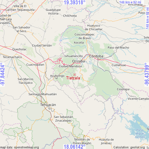
Tlatzala GPS coordinates[2]
18° 43' 42.996" North, 97° 8' 27.996" West
| Map corner | latitude | longitude |
|---|---|---|
| Upper-left | 19.39318°, | -97.84424° |
| Center: | 18.72861°, | -97.14111° |
| Lower-right: | 18.06142°, | -96.43799° |
| Map W x H: | 148.1×148.1 km | = 92×92mi |
| max Lat: | 32.7° ⇑69.9% North |
| Tlatzala: | 18.72861° |
| min Lat: | ⇓30.1% South 14.53588° |
| min Long | Tlatzala | max Long |
| -117.105° | -97.14111° | -86.73105° |
| W 73.1%⇐ | ⇒26.9% E |
Elevation
Elevation of Tlatzala is 2262 m = 7421 ft, and this is 1008.3 m = 3308 ft above average elevation for this country.
| Max E: |
3497 m = 11473 ft | 14.9% |
| Tlatzala | 2262 m 7421 ft | |
| Avg. | 1253.7 m = 4113 ft | |
Min E: |
-1 m = -3 ft | 85.1% |
See also: Mexico elevation on elevation.city.
Geographical zone
Tlatzala is located in North Torrid zone (between Equator and Tropic of Cancer). Distance of this Northern Tropic circle is 523.5 km =325.3 mi to North.| Distance of | km | miles | from Tlatzala |
|---|---|---|---|
| North Pole | 7924.6 | 4924.1 | to North |
| Arctic Circle | 5318.7 | 3304.9 | to North |
| Tropic Cancer | 523.5 | 325.3 | to North |
| Equator | 2082.4 | 1293.9 | to South |


Nearby cities:
15 places around Tlatzala: (largest is in red/bold)
• Atexcalco
4.7 km =2.9 mi,  250°
250°
• Barrio de Tetzmola
4.7 km =2.9 mi,  344°
344°
• Huitzila
3.3 km =2.1 mi, 250°
• Huixtitla
6.1 km =3.8 mi,  294°
294°
• Mexcala
4.4 km =2.7 mi,  214°
214°
• Monterrey
1.4 km =0.9 mi, 336°
• Necoxtla
5.7 km =3.5 mi,  346°
346°
• Soledad Atzompa
3.1 km =1.9 mi, 341°
• Soledad Atzompa
4.6 km =2.9 mi,  265°
265°
• Tetlatzinga
5.9 km =3.7 mi,  230°
230°
• Tlalpan
2.6 km =1.6 mi,  309°
309°
• Tlatilpa
0.7 km =0.4 mi,  331°
331°
• Tzoncolco
5.3 km =3.3 mi,  16°
16°
• Xiquila
5.9 km =3.7 mi, 249°
• Xonotla
2 km =1.2 mi, 327°
Sources, notices
• [Note1] Compared only with cities in Mexico existing in our database
• [Src1] Map data: © OpenStreetMap contributors (CC-BY-SA)
• [Src2] Other city data from geonames.org with taken over terms of usage.
• [Src3] Geographical zone / Annual Mean Temperature by Robert A. Rohde @ Wikipedia
