Antón Lizardo geodata
Antón Lizardo (Veracruz) is a populated place; located in Mexico in America/Mexico_City (GMT-6) time zone. With population of 6,003 people, there are 1556 cities with bigger population in this country. Compared to other cities in Mexico, 63.7% of cities are located further ↑North; 82.3% of cities are located further ←West and 97.5% of cities have higher elevation than Antón Lizardo. Note1


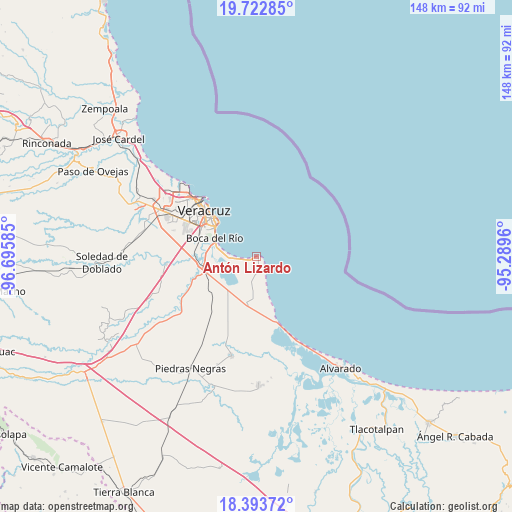
Antón Lizardo GPS coordinates[2]
19° 3' 34.632" North, 95° 59' 33.792" West
| Map corner | latitude | longitude |
|---|---|---|
| Upper-left | 19.72285°, | -96.69585° |
| Center: | 19.05962°, | -95.99272° |
| Lower-right: | 18.39372°, | -95.2896° |
| Map W x H: | 147.8×147.8 km | = 91.8×91.8mi |
| max Lat: | 32.7° ⇑63.7% North |
| Antón Lizardo: | 19.05962° |
| min Lat: | ⇓36.3% South 14.53588° |
| min Long | Antón Lizardo | max Long |
| -117.105° | -95.99272° | -86.73105° |
| W 82.3%⇐ | ⇒17.7% E |
Elevation
Elevation of Antón Lizardo is 9 m = 30 ft, and this is 1244.7 m = 4084 ft below average elevation for this country.
| Max E: |
3497 m = 11473 ft | 97.5% |
| Avg. | 1253.7 m = 4113 ft | |
| Antón Lizardo | 9 m = 30 ft | |
Min E: |
-1 m = -3 ft | 2.5% |
See also: Mexico elevation on elevation.city.
Geographical zone
Antón Lizardo is located in North Torrid zone (between Equator and Tropic of Cancer). Distance of this Northern Tropic circle is 486.7 km =302.4 mi to North.| Distance of | km | miles | from Antón Lizardo |
|---|---|---|---|
| North Pole | 7887.8 | 4901.3 | to North |
| Arctic Circle | 5281.9 | 3282 | to North |
| Tropic Cancer | 486.7 | 302.4 | to North |
| Equator | 2119.2 | 1316.8 | to South |


Nearby cities:
15 places around Antón Lizardo: (largest is in red/bold)
• Boca del Rio
12.7 km =7.9 mi,  293°
293°
• El Bayo
8.6 km =5.3 mi,  164°
164°
• El Tejar
17.8 km =11.1 mi,  275°
275°
• El Zapote
6.1 km =3.8 mi,  176°
176°
• Fraccionamiento Arboledas San Ramón
17.7 km =11 mi, 282°
• Fraccionamiento las Lomas
11 km =6.8 mi, 276°
• Herón Proal
12.1 km =7.5 mi,  244°
244°
• La Gloria
14.4 km =8.9 mi,  251°
251°
• La Laguna y Monte del Castillo
12.3 km =7.6 mi,  226°
226°
• La Piedra
14 km =8.7 mi,  189°
189°
• Los Robles
16.3 km =10.1 mi, 233°
• Medellín de Bravo
17.4 km =10.8 mi,  269°
269°
• Paso Colorado
15.2 km =9.4 mi, 272°
• Paso del Toro
15.3 km =9.5 mi,  259°
259°
• Playa de la Libertad
11.3 km =7 mi, 283°
Sources, notices
• [Note1] Compared only with cities in Mexico existing in our database
• [Src1] Map data: © OpenStreetMap contributors (CC-BY-SA)
• [Src2] Other city data from geonames.org with taken over terms of usage.
• [Src3] Geographical zone / Annual Mean Temperature by Robert A. Rohde @ Wikipedia
