El Bayo geodata
El Bayo (Veracruz) is a populated place; located in Mexico in America/Mexico_City (GMT-6) time zone. With population of 524 people, there are 16113 cities with bigger population in this country. Compared to other cities in Mexico, 65% of cities are located further ↑North; 82.3% of cities are located further ←West and 91.6% of cities have higher elevation than El Bayo. Note1


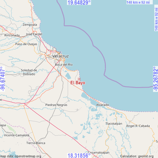
El Bayo GPS coordinates[2]
18° 59' 5.1" North, 95° 58' 15.384" West
| Map corner | latitude | longitude |
|---|---|---|
| Upper-left | 19.64829°, | -96.67407° |
| Center: | 18.98475°, | -95.97094° |
| Lower-right: | 18.31856°, | -95.26782° |
| Map W x H: | 147.9×147.9 km | = 91.9×91.9mi |
| max Lat: | 32.7° ⇑65% North |
| El Bayo: | 18.98475° |
| min Lat: | ⇓35% South 14.53588° |
| min Long | El Bayo | max Long |
| -117.105° | -95.97094° | -86.73105° |
| W 82.3%⇐ | ⇒17.7% E |
Elevation
Elevation of El Bayo is 20 m = 66 ft, and this is 1233.7 m = 4048 ft below average elevation for this country.
| Max E: |
3497 m = 11473 ft | 91.6% |
| Avg. | 1253.7 m = 4113 ft | |
| El Bayo | 20 m = 66 ft | |
Min E: |
-1 m = -3 ft | 8.4% |
See also: Mexico elevation on elevation.city.
Geographical zone
El Bayo is located in North Torrid zone (between Equator and Tropic of Cancer). Distance of this Northern Tropic circle is 495 km =307.6 mi to North.| Distance of | km | miles | from El Bayo |
|---|---|---|---|
| North Pole | 7896.2 | 4906.5 | to North |
| Arctic Circle | 5290.3 | 3287.2 | to North |
| Tropic Cancer | 495 | 307.6 | to North |
| Equator | 2110.9 | 1311.7 | to South |


Nearby cities:
15 places around El Bayo: (largest is in red/bold)
• Antón Lizardo
8.6 km =5.3 mi,  344°
344°
• Boca del Rio
19.3 km =12 mi,  313°
313°
• El Zapote
2.9 km =1.8 mi,  318°
318°
• Fraccionamiento las Lomas
16.3 km =10.1 mi, 305°
• Herón Proal
13.6 km =8.5 mi,  283°
283°
• La Gloria
16.4 km =10.2 mi, 282°
• La Laguna y Monte del Castillo
11.3 km =7 mi,  269°
269°
• La Piedra
7.1 km =4.4 mi,  220°
220°
• Los Robles
15.5 km =9.6 mi, 265°
• Mata Cabestro (La Víbora)
13 km =8.1 mi,  232°
232°
• Paloma Sola
16.9 km =10.5 mi, 218°
• Paso Colorado
19.6 km =12.2 mi,  297°
297°
• Paso del Toro
18.2 km =11.3 mi,  287°
287°
• Playa de la Libertad
17.2 km =10.7 mi, 309°
• Salinas
10.9 km =6.8 mi,  164°
164°
Sources, notices
• [Note1] Compared only with cities in Mexico existing in our database
• [Src1] Map data: © OpenStreetMap contributors (CC-BY-SA)
• [Src2] Other city data from geonames.org with taken over terms of usage.
• [Src3] Geographical zone / Annual Mean Temperature by Robert A. Rohde @ Wikipedia
