Atotonilco geodata
Atotonilco (Morelos) is a populated place; located in Mexico in America/Mexico_City (GMT-6) time zone. With population of 3,175 people, there are 2842 cities with bigger population in this country. Compared to other cities in Mexico, 70.8% of cities are located further ↑North; 53.1% of cities are located further ←West and 53.9% of cities have higher elevation than Atotonilco. Note1


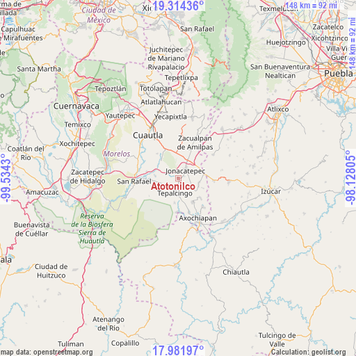
Atotonilco GPS coordinates[2]
18° 38' 58.092" North, 98° 49' 52.212" West
| Map corner | latitude | longitude |
|---|---|---|
| Upper-left | 19.31436°, | -99.5343° |
| Center: | 18.64947°, | -98.83117° |
| Lower-right: | 17.98197°, | -98.12805° |
| Map W x H: | 148.1×148.1 km | = 92×92mi |
| max Lat: | 32.7° ⇑70.8% North |
| Atotonilco: | 18.64947° |
| min Lat: | ⇓29.2% South 14.53588° |
| min Long | Atotonilco | max Long |
| -117.105° | -98.83117° | -86.73105° |
| W 53.1%⇐ | ⇒46.9% E |
Elevation
Elevation of Atotonilco is 1251 m = 4104 ft, and this is 2.7 m = 9 ft below average elevation for this country.
| Max E: |
3497 m = 11473 ft | 53.9% |
| Avg. | 1253.7 m = 4113 ft | |
| Atotonilco | 1251 m = 4104 ft | |
Min E: |
-1 m = -3 ft | 46.1% |
See also: Mexico elevation on elevation.city.
Geographical zone
Atotonilco is located in North Torrid zone (between Equator and Tropic of Cancer). Distance of this Northern Tropic circle is 532.3 km =330.8 mi to North.| Distance of | km | miles | from Atotonilco |
|---|---|---|---|
| North Pole | 7933.4 | 4929.6 | to North |
| Arctic Circle | 5327.5 | 3310.4 | to North |
| Tropic Cancer | 532.3 | 330.8 | to North |
| Equator | 2073.6 | 1288.5 | to South |


Nearby cities:
15 places around Atotonilco: (largest is in red/bold)
• Amacuitlapilco
5.6 km =3.5 mi,  21°
21°
• Amayuca
9 km =5.6 mi, 22°
• Chalcatzingo
7.5 km =4.7 mi,  53°
53°
• Huitchila
10 km =6.2 mi,  263°
263°
• Huitzililla
8.5 km =5.3 mi,  305°
305°
• Ixtlilco el Chico
10.3 km =6.4 mi,  189°
189°
• Jantetelco
9.5 km =5.9 mi,  36°
36°
• Jonacatepec
4.6 km =2.9 mi, 40°
• Marcelino Rodríguez (San Ignacio)
12.1 km =7.5 mi,  130°
130°
• Telixtac
11.5 km =7.1 mi,  149°
149°
• Tenango
8.9 km =5.5 mi,  109°
109°
• Tepalcingo
6.2 km =3.9 mi, 193°
• Tetelilla
7.3 km =4.5 mi,  123°
123°
• Unidad Habitacional Mariano Matamoros
11.1 km =6.9 mi,  348°
348°
• Xalostoc
10.8 km =6.7 mi,  318°
318°
Sources, notices
• [Note1] Compared only with cities in Mexico existing in our database
• [Src1] Map data: © OpenStreetMap contributors (CC-BY-SA)
• [Src2] Other city data from geonames.org with taken over terms of usage.
• [Src3] Geographical zone / Annual Mean Temperature by Robert A. Rohde @ Wikipedia
